Highlights van Armenië
Natuur
- Sevan meer - een eindeloos meer met grootse vergezichten
- Mount Ararat - de beroemdste berg van Armenie


Sport en avontuur
- paardrijden in de Tavush regio
Mooiste routes
- Armenia Erfgoederen Route - prachtige fietsroute langs de belangrijkste hoogteepunten van Armenie
Overige mooiste bezienswaardigheden, evenementen, activiteiten en attracties
- Karabakh - een enclave die tot Azerbeidzjan hoort, en alleen via Armenie te bezoeken is
World Heritage Sites
- geen

Typisch
| nationale gerechten | Harissa |
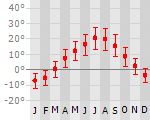
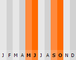
Klimaat
| Kenmerken |
|
| Temperatuur | Beste tijd voor een reis |
|
|
Typisch
| Officiële landsnaam | Republiek Armenië |
| Hoofdstad | Yerevan |
| Nationaliteit | Armenier |
| Talen | overig, russisch |
| Visum nodig? | Ja |
| Munteenheid | Dram (AMD) |
| Regeringsvorm | republiek |
| Grootte t.o.v. Nederland | 1.4 keer kleiner |
| Bevolking | 3.0 miljoen |
| Bevolkingsdichtheid t.o.v. Nederland | 4.0 keer lager |
| Laagste punt | 400 m |
| Hoogste punt | 4090 m |
Tags
Bergen wandelen rotsklimmen windsurfen zonnebaden kamperen skieen kloosters bergklimaat WintersportInteressante boeken over Armenië
-
Wegenkaart - Landkaart Kaukasus - Caucasus | Gizi Map | 13.25 €
.jpg)
The Caucasus at 1:1,000,000 from Gizi Map, presenting the region in a road edition with relief shading to show its topography and make the ... meer
The Caucasus at 1:1,000,000 from Gizi Map, presenting the region in a road edition with relief shading to show its topography and make the road network stand out better against the background. Coverage includes the southern republics of Russia. International boundaries are clearly marked.Within Georgia the map indicates the boundaries of South Ossetia, Abkhazia and Adjara; in Azerbaijan the border of Nagorno Karabach and the ceasefire line are marked. Coverage within Russia extends north of Krasnodar and Stavropol, with boundaries of individual republics including Chechnya, North Ossetia and Dagestan. Place names are shown in Latin alphabet, but within Georgia, Armenia and Russia larger towns are also named in local script.Relief shading with plenty of names of geographical features such as individual mountain ranges, peaks, swamps, salt flats, etc, presents the topography. Road network is graded in six types, with driving distances on main and selected connecting routes. Railway lines are included and local airports are marked. Symbols highlight various places of interest. Latitude and longitude lines are drawn at 1° intervals. The index, arranged by country, is on the reverse. Multilingual map legend includes English.A separate insets presents at-a-glance the political and administrative division of the region. -
Reisgids Lonely Planet Georgia, Armenia & Azerbaijan - Georgië, Armenië & Azerbeidzjan | Lonely Planet | 21.95 €
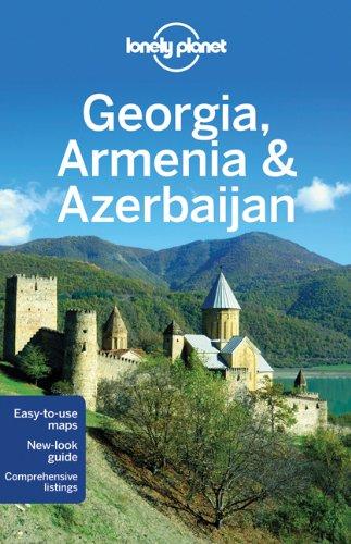
De perfecte reisgids voor zowel de georganiseerde als de zelfstandige reiziger. Naast een algemene inleiding van het land / streek vol met praktisch... meer
De perfecte reisgids voor zowel de georganiseerde als de zelfstandige reiziger. Naast een algemene inleiding van het land / streek vol met praktische informatie over hoe je er het beste kunt reizen: slapen, eten, vervoer, excursies ... alles kun je er in vinden.
All three of these countries afford unlimited opportunities for travellers to get out amid spectacular nature - the snowy Caucasus, the verdant valleys of Armenia, semitropical southern Azerbaijan. The untrammelled scenery is decorated with fascinating castles, palaces, churches and mosques from an extraordinarily rich history.
Authors who have travelled for years in the region, plus interviews with locals
Increased coverage on food and drink
Greater regional coverage
Accommodation recommendations
Reis en Vakantie Top 10Armenië is vertegenwoordigd in de volgende reis top10's: |

- © 2010-2015 top10gezien.nl
- over deze site
- disclaimer
- adverteren
- contact