Highlights van Japan
Natuur
- Kushiro Nationaal Park - de kraanvogel leeft hier in de veelkleurige omgeving van moerassen en veengebieden


Cultuur
- Het Kasteel Hime-ji - het Kasteel van de witte reiger
- Vliegveld Kansai - een luchthaven gebouwd op zee
World Heritage Sites
- Boeddhistische monumenten in het Horyuji-gebied
- Kasteel Himeji
- Yakushima
- Shirakami Sanchi
- Historische monumenten van oud-Kioto (Kioto & Uji en Otsu)
- Historische dorpen van Shirakawago en Gokayama
- Vredesmonument van Hiroshima (Genbaku Dome)
- Itsukushima-schrijn
- Historische monumenten van oud-Nara
- Schrijnen en tempels van Nikko
- Gusuku-locatie en gerelateerde plaatsen van het Koninkrijk Riukiu
- Drie heilige plaatsen en de pelgrimsroute in het Kii-gebergte
- Shiretoko
- Zilvermijn Iwami Ginzan en zijn cultuurlandschap

Typisch
| nationale gerechten | sushi en sashimi |
| nationale dranken | sake |
Klimaat
| Kenmerken |
|
| Temperatuur | Beste tijd voor een reis |
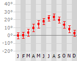
|
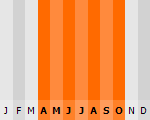
|
Typisch
| Officiële landsnaam | Japan |
| Hoofdstad | Tokyo |
| Nationaliteit | Japanner |
| Talen | overig |
| Visum nodig? | Nee |
| Munteenheid | Yen (JPY) |
| Regeringsvorm | constitutionele monarchie |
| Grootte t.o.v. Nederland | 9.1 keer groter |
| Bevolking | 127.3 miljoen |
| Bevolkingsdichtheid t.o.v. Nederland | 1.2 keer lager |
| Laagste punt | -4 m |
| Hoogste punt | 3776 m |
Interessante boeken over Japan
-
Wegenkaart - landkaart Noord Japan - Japan North & Hokkaido Travel Reference map 1:800.000 | ITMB | 10.95 €
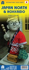
Een degelijke kaart met aanduidingen van o.a. nationale parken, vliegveld, benzinepomp, dirt-roads en kleine plattegrond van hoofdstad. Als overzich... meer
Een degelijke kaart met aanduidingen van o.a. nationale parken, vliegveld, benzinepomp, dirt-roads en kleine plattegrond van hoofdstad. Als overzichtskaart goed te gebruiken.
In one sense, this is a brand new map, in that the artwork is all brand new. In another sense, it is our map of Hokkaid re-worked into a more marketable format. In any case, it is a very much-needed sectional map of that portion of Japan from Tokyo northwards. Hokkaido is actually one of the most interesting parts of Japan to visit. The island was opened to settlement only after the Ameicans forced Japan to allow contacts with foreign countries in 1868, thanks to Admiral Peary and Gunboat Diplomacy. Hokkaido has been relatively untouched by Japan’s rush to economic dominance, so is the country’s skiing capital in winter and the part of Japan most similar to America. An inset map of Sapporo is included. The other side shows the main island of the country from Nagoya and Toyama (which are considerably west of Tokyo) through Tokyo itself (inset map included) north all the way to Aomori and the tunnel to Hokkaido. All known touristic sites are included, as well as the famous Shinkensen rail lines (and regular rail lines as well), motorways, all main and secondary highways, and everything is shown at a better scale that would be possible on our Japan map. ITMB also publishes a map of the southern portion of the country, called Kyoto and Southern Japan. This map is printed on paper, double-sided.
-
Stadplattegrond - landkaart Tokyo | Insight Guide Fleximap | 10.25 €
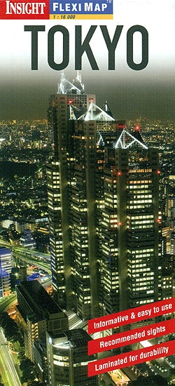
This laminated Fleximap of Tokyo contains five maps, including one of the greater city region and street maps of central neighbourhoods. It also giv... meer
This laminated Fleximap of Tokyo contains five maps, including one of the greater city region and street maps of central neighbourhoods. It also gives details of more than 20 recommended sights and places to visit - from the Imperial Palace to Mount Fuji and Hakone - as well as useful travel information, climate tables and local transport details. Map scale 1: 16.000 - 1: 335,000

Vakantiebestemmingen met vergelijkbare kenmerkenMisschien bent u ook geïnteresseerd in andere vakantielanden met de volgende kenmerken: |
Reis en Vakantie Top 10Japan is vertegenwoordigd in de volgende reis top10's:
|

- © 2010-2015 top10gezien.nl
- over deze site
- disclaimer
- adverteren
- contact