Highlights van Maleisië

Maleisië is Azië voor beginners. De bevolking spreekt er goed Engels, het welvaartsniveau is (bijna) dat van een Westerse land, evenals de hygiënische standaarden. Zelfs op Borneo (Sarawak en Sabah) is de toegankelijkheid van natuurgebieden zeer goed, volgens sommigen zelfs overgeorganiseerd. Het betekent wel een onbezorgde vakantie, met veel hoogtepunten die voor het oprapen liggen.
Natuur
- Taman Negara - de oudste oerbossen ter wereld
- en toegankelijk


Cultuur
- Petronas Twin Towers - moderne torens ontworpen volgens klassieke islamitische architectuur
World Heritage Sites
- Nationaal park Gunung Mulu
- Park Kinabalu

Typisch
| nationale gerechten | nasi lemak |
| nationale dranken | Teh tarik |
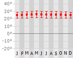
Klimaat
| Temperatuur | Beste tijd voor een reis |
|
|
Typisch
| Officiële landsnaam | Maleisië |
| Hoofdstad | Kuala Lumpur |
| Nationaliteit | Maleisier |
| Talen | Maleisisch-Indonesisch |
| Visum nodig? | Nee |
| Munteenheid | Ringgit (MYR) |
| Regeringsvorm | constitutionele monarchie |
| Grootte t.o.v. Nederland | 7.9 keer groter |
| Bevolking | 25.3 miljoen |
| Bevolkingsdichtheid t.o.v. Nederland | 5.2 keer lager |
| Laagste punt | 0 m |
| Hoogste punt | 4100 m |
Don't do this
- Mount Kinabalu beklimmen - over de top, overtoeristisch en niet de mooiste beklimming
Exotische ziekten
- malaria
- hepatitis A
- typhus
- dengue
Interessante boeken over Maleisië
-
Landenreeks Maleisië | 11.90 €
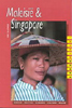
Niet zozeer een reisgids, maar meer een journalistieke benadering van verschillende algemene aspecten van het land als onderwijs, economie, politiek e... meer
Niet zozeer een reisgids, maar meer een journalistieke benadering van verschillende algemene aspecten van het land als onderwijs, economie, politiek en geschiedenis.
-
Woordenboek Taalgids Malay phrasebook - Maleis | Lonely Planet | 7.25 €
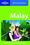
Handige taalgids voor basis Malay. Zowel woorden, phonetisch uitgelegd, als zinnen. Engels / Malay. Lonely Planet The national language of Malaysia i... meer
Handige taalgids voor basis Malay. Zowel woorden, phonetisch uitgelegd, als zinnen. Engels / Malay. Lonely Planet
The national language of Malaysia is a surprisingly easy language to wrap your tongue around. Words are largely pronounced phonetically - so dive in and leave that language barrier in the dust.
two-way dictionary
guide to pronunciation and phrase-building
practicalities - getting around, greeting the locals
decoding menus and brushing up on Malay table etiquette
Vakantiebestemmingen met vergelijkbare kenmerkenMisschien bent u ook geïnteresseerd in andere vakantielanden met de volgende kenmerken: |
Reis en Vakantie Top 10Maleisië is vertegenwoordigd in de volgende reis top10's:
|

- © 2010-2015 top10gezien.nl
- over deze site
- disclaimer
- adverteren
- contact