Highlights van Mongolië


World Heritage Sites
- Het bekken van Uvs Nuur
- Het cultuurlandschap van de Orchonvallei

Typisch
| nationale gerechten | buuz |
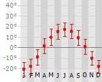
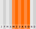
Klimaat
| Kenmerken |
|
| Temperatuur | Beste tijd voor een reis |
|
|
Typisch
| Officiële landsnaam | Mongolië |
| Hoofdstad | Ulam Batar |
| Nationaliteit | Mongolier |
| Talen | overig, russisch |
| Visum nodig? | Ja |
| Munteenheid | Togrog/ Tugrik (MNT) |
| Regeringsvorm | republiek |
| Grootte t.o.v. Nederland | 37.7 keer groter |
| Bevolking | 3.0 miljoen |
| Bevolkingsdichtheid t.o.v. Nederland | 209.3 keer lager |
| Laagste punt | 518 m |
| Hoogste punt | 4374 m |
Interessante boeken over Mongolië
-
Woordenboek Taalgids Mongolian phrasebook - Mongools | Lonely Planet | 7.25 €
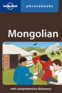
Handige taalgids voor basis Mongolian. Zowel woorden, phonetisch uitgelegd, als zinnen. Engels / mongolian. Lonely Planet Agglutination, vowel harmon... meer
Handige taalgids voor basis Mongolian. Zowel woorden, phonetisch uitgelegd, als zinnen. Engels / mongolian. Lonely Planet
Agglutination, vowel harmony - you may not know what they mean, but this nifty little guide to Mongol will get you well on the way to mastering how they sound. You want your mare's milk warmed? You got it.
two-way dictionary
guide to pronunciation and phrase-building
practicalities - how to hire a horse, how to pronounce 'Call off the dogs!'
script in Mongolian Cyrillic - if in doubt, just point -
Reisgids Lonely Planet Mongolia - Mongolië | Lonely Planet | 22.95 €
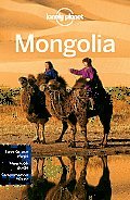
De perfecte reisgids voor zowel de georganiseerde als de zelfstandige reiziger. Naast een algemene inleiding van het land / streek vol met praktisch... meer
De perfecte reisgids voor zowel de georganiseerde als de zelfstandige reiziger. Naast een algemene inleiding van het land / streek vol met praktische informatie over hoe je er het beste kunt reizen: slapen, eten, vervoer, excursies ... alles kun je er in vinden.
Mongolia's capital, Ulaanbaatar, may be a hotbed of progressive attitudes, but in the rest of the 'Land of the Blue Sky', life remains pretty much the same - horses outnumber people, nomads still move camp each season and on long-distance bus rides you'll be serenaded by passengers singing folk tunes.
Best activities: yak-carting, horse-trekking, hiking
In a land short on signposts, GPS coordinates locate the hotspots
Comprehensive Culture chapter with advice on local customs and etiquette
Rock climbing opportunities in the Gobi and mountain biking in Terelj and Khentii
Reis en Vakantie Top 10Mongolië is vertegenwoordigd in de volgende reis top10's:
|

- © 2010-2015 top10gezien.nl
- over deze site
- disclaimer
- adverteren
- contact