Highlights van Venezuela
Natuur
- Sierra Nevada de Mérida - bergketen in tropisch regenwoud
- Canaima Nationaal Park - afgelegen gebied van tafelbergen
- en natuurlijk de Angel Falls
- een van de hoogste watervallen ter wereld


World Heritage Sites
- Coro met zijn haven
- Nationaal park Canaima De universiteitsstad Caracas

Typisch
| nationale gerechten | pabellón criollo |
| nationale dranken | Papelón con limón |
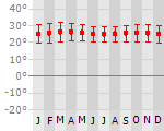
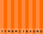
Klimaat
| Kenmerken |
|
| Temperatuur | Beste tijd voor een reis |
|
|
Typisch
| Officiële landsnaam | Bolivariaanse Republiek Venezuela |
| Hoofdstad | Caracas |
| Nationaliteit | Venezolaan |
| Talen | Spaans |
| Visum nodig? | Nee |
| Munteenheid | Bolivar (VEB) |
| Regeringsvorm | federale republiek |
| Grootte t.o.v. Nederland | 22.0 keer groter |
| Bevolking | 26.4 miljoen |
| Bevolkingsdichtheid t.o.v. Nederland | 13.8 keer lager |
| Laagste punt | 0 m |
| Hoogste punt | 5007 m |
Exotische ziekten
- malaria
- hepatitis A
- dengue
Interessante boeken over Venezuela
-
Wegenkaart - Landkaart Venezuela | Borch Maps | 10.25 €
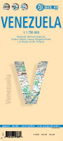
Geplastificeerde wegenkaart van Venezuela voor toeristisch gebruik. Met stadsplattegrond en index. Our soft-laminated folded map of Venezuela show... meer
Geplastificeerde wegenkaart van Venezuela voor toeristisch gebruik. Met stadsplattegrond en index.
Our soft-laminated folded map of Venezuela shows: Venezuela 1:1 750 000, Territorio Amazonas 1:2 000 000, Caracas 1:17 000, Greater Caracas 1:450 000, Isla de Margarita 1:250 000, Porlamar 1:15 000, Islas Los Roques 1:500 000, Venezuela administrative & time zones. Borch Maps are easy to fold, durable and water-repellent with a wipeable surface. Borch Maps show hotels, museums, monuments, markets, public transport, top sights and points of interest, useful statistics, conversion charts for temperatures, weights and measurements, climate charts showing temperatures, sunshine hours, precipitation and humidity, overview maps, time zones, and much more...
When the Spanish conquistadors first reached the shores of Lake Maracaibo, they found an Indian pile village reminded them of Venice. So they named the village Venezuela or Little Venice. Little Venice vanished into colonial darkness, ending with the declaration of independence on 5 July 1811. Today, Lake Maracaibo bristles with oil derricks pumping black gold, which has made Venezuela one of the wealthiest countries in South America. For tourists, however, the country's greatest wealth lies in its varied landscape, in its unique flora and fauna. The Llanos Steppe (the "Serengeti of South America"), for example, is the habitat of howling apes, foxes, anteaters and the shy ocelot. The rain forests are full of undiscovered plant species; the Guyana Plateau inspired Conan Doyle‘s Sherlock Holmes; and the highest waterfall in the world, Salto del Angel, roars from a height of 980 meters. To top it all off, Venezuela has gorgeous beaches, comfortable hotels and a delicious cuisine enriched by tropical fruit flavors. -
Wegenkaart - landkaart Venezuela | Freytag & Berndt | 10.50 €
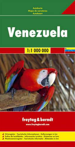
Gedetailleerde, tweezijdige landkaart van Venezuela, prima geschikt voor planning en rondtrekken . De berijdbare wegen zijn goed weergeven, zowel de... meer
Gedetailleerde, tweezijdige landkaart van Venezuela, prima geschikt voor planning en rondtrekken . De berijdbare wegen zijn goed weergeven, zowel de hoofdwegen als provinciale en lokale wegen; wegnummers worden vermeld. Afstanden tussen plaatsen zijn in kilometers op de kaart ingetekend, daarnaast worden ook op belangrijke plekken benzinepompen gemarkeerd.
In het kaartbeeld wordt door middel van schaduw het reliëf weergegeven en soms enkele punten in het landschap met de daadwerkelijke hoogte. Provinciegrenzen zijn goed terug te vinden, nationale parken en reservaten ook. Met allerhande symbolen worden toeristische bezienswaardigheden weergegeven als monumenten, historisch belangrijke plekken en uitzichtpunten. In bepaalde plaatsen zijn hotels en campings te vinden, luchthavens, treinverbindingen en havens vindt u er ook op!

Vakantiebestemmingen met vergelijkbare kenmerkenMisschien bent u ook geïnteresseerd in andere vakantielanden met de volgende kenmerken: |
Reis en Vakantie Top 10Venezuela is vertegenwoordigd in de volgende reis top10's: |

- © 2010-2015 top10gezien.nl
- over deze site
- disclaimer
- adverteren
- contact