Highlights van Australië

"Down Under" Australië, van deze verre reis krijg je zeker geen spijt. Het leven is er goed ingericht voor backpackers; je kunt reizen en werken hier prima combineren. Naast heel toeristische plaatsen zoals Sydney, zijn er voldoende reis bestemmingen waar je heel ver van de bewoonde wereld bent. Ook voor andere adventure zoals snorkelen en duiken ben je in Australië op de juiste plek.
Natuur
- Ayers Rock - een grote beroemde rotsformatie van zandsteen
- Devils Marbles - lanschap bezaaid met granieten boulders
- Tasmanië - prachtig bergen en meren gebied
- Pinnacles - kalkstenen pilaren in het Nanbung Nationale Park
- Kakadu - enorm nationaal park waar ook de aboriginals zich thuisvoelen
- Fraser eiland - het grootste zandeiland ter wereld
- Blue Mountains - een prachtig natuurpark met diepe ravijnen en eucalyptusbomen
- Lord Howe eiland
- de Olgas - gigantische monolieten, puntige rotsformaties
- Ningaloo Reef - buitengewoon mooi rif aan de westkust van Australie, nog niet overlopen door toeristen zoals het Great Barrier, maar wel de mogelijkheid te snorkelen en duiken en walvishaaien, reuzen roggen en haaien te spotten
- Grote Barrière rif - het grootste rif ter wereld goed voor vele uren snorkelen en duiken
- Bungle Bungles - landschap vol met bizarre rotsformaties


Cultuur
- Aboriginals - aboriginalscultuur in Arnhemland: Kakadu Nationaal Park - graslanden/ boomsavanna en rotsschilderingen van Aboriginals
- Sydney Opera House - een waanzinnig gebouw in expressionistische bouwstijl
- De haven van Sydney
Sport en avontuur
- Zwemmen met walvishaaien bij Ningaloo Reef
Mooiste routes
- Great Ocean Road - schilderachtige 273 km lange weg langs de kust van Australië
- Outback - hier kun je echt de wildernis in, geen mens tegen komen en gewild of ongewild verdwalen. Het is het land van de Aboriginals en Uluru (Ayers Rock)
- Indian Pacific treinreis
- De treinreis van Alicesprings naar Darwin
Overige mooiste bezienswaardigheden, evenementen, activiteiten en attracties
- Dolfijnen voeren bij Monkey Mia
- Fraser Eiland - het grootste zandeiland ter wereld met kilometers lange witte bounty-stranden
- Kings Canyon - spectaculaire kloof van rood gesteente
- Sidney - wereldstad aan het water met een relaxte atmosfeer
- Wijn proeven uit de Barrossa Vallei
World Heritage Sites
- Great Barrier Rif
- Kakadu Nationaal Park
- Willandra Meren Regio
- Lord Howe eilanden groep
- Tasmaanse Wildernis
- Gondwana Regenwoud van Australië
- Uluru-Kata Tjuta Nationaal Park
- Wet Tropics van Queensland
- Haaien baai in West Australië
- Fraser Eiland
- Australische Fossiele Zoogdieren terrein Riversleigh / Naracoorte
- Heard en McDonald Eilanden
- Macquarie Eiland
- Greater Blue Mountains gebied
- Purnululu Nationaal Park
- Royal Exhibition Building and Carlton Gardens
- Sydney Opera House

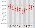
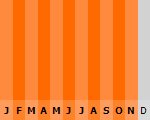
Klimaat
| Kenmerken |
|
| Temperatuur | Beste tijd voor een reis |
|
|
Typisch
| Officiële landsnaam | Gemenebest Australië |
| Hoofdstad | Canberra |
| Nationaliteit | Australier |
| Talen | engels |
| Visum nodig? | Ja |
| Munteenheid | Australische Dollar (AUD) |
| Regeringsvorm | federale parlementaire democratie |
| Grootte t.o.v. Nederland | 185.1 keer groter |
| Bevolking | 20.6 miljoen |
| Bevolkingsdichtheid t.o.v. Nederland | 149.6 keer lager |
| Laagste punt | -15 m |
| Hoogste punt | 2229 m |
Tags
Zee en strand tropisch woestijn steppe savanne Wintersport Duiken Kamperen Backpacken relaxed mountainbiken raften kanoen surfen klimmen eindeloze strandenInteressante boeken over Australië
-
Landkaart - wegenkaart Australasia | Globetrotter | 10.75 €
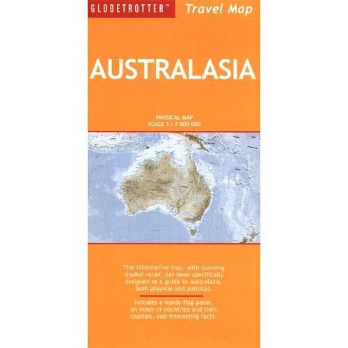
This informative map, with stunning shaded relief, features a large-scale physical projection of the continent and a detailed political map complete... meer
This informative map, with stunning shaded relief, features a large-scale physical projection of the continent and a detailed political map complete with up-to-date statistics. The maps are ideal for home, school and office use, and contain an index of countries and their capitals, a handy flag panel and interesting country facts.
-
Landkaart - wegenkaart Tasmanië - Tasmania state map | Hema maps | 11.25 €
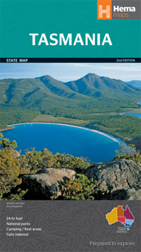
Op deze kaart staat Tasmanië in zijn geheel op 1 deel van de kaart. Goede, overzichtelijke, leesbare kaart van het hele eiland. Nationale Par... meer
Op deze kaart staat Tasmanië in zijn geheel op 1 deel van de kaart.
Goede, overzichtelijke, leesbare kaart van het hele eiland. Nationale Parken zijn er goed op te vinden en de afstanden worden weergegeven. Op de achterkant nog deelkaartjes van enkele steden en NP s.
Great for travel planning, Hema's Tasmania state map clearly shows highways, minor and secondary roads, national and state routes and fully-indexed cities, towns and localities. Detailed road distances are also shown.The flipside of the map features loads of insets covering various bits and pieces throughout Tasmania including street maps of Hobart, Launceston, Devonport and Burnie as well as a couple of regional maps covering the areas around Hobart and Launceston. There's also some photos showing highlights throughout the state.The map features:Camping areasRest areas24 hour fuel locationsOutback fuel stopsCaravan parksNational parksA full indexPoints of interestA distance gridThe map folds out to 1000 x 700 mm
Vakantiebestemmingen met vergelijkbare kenmerkenMisschien bent u ook geïnteresseerd in andere vakantielanden met de volgende kenmerken: |
Reis en Vakantie Top 10Australië is vertegenwoordigd in de volgende reis top10's:
|

- © 2010-2015 top10gezien.nl
- over deze site
- disclaimer
- adverteren
- contact