Highlights van Canada

Ben je toe aan ruige natuur, ongekende outdoor mogelijkheden, uitgestrekte landschappen en eindeloze vergezichten, dan is dit gigantische land misschien jouw volgende reisbestemming. Voor een eenmalige reis is dit op een-na-grootste land ter wereld in ieder geval niet genoeg. Behalve wilde dieren zoals de (bruine) beer, bergen en een duizenden kilometers lange kustlijn, vind je hier een vriendelijke bevolking
Natuur
- Ellesmere - een enorm & kaal eiland met gletsjers
- Wood Buffalo Nationaal Park - uitgestrekte toendra en meanderende rivieren
- Jasper National Park - een hoogalpienie dierenwereld waar zwarte beren, lynxen en poema's ronddwalen
- Banff National Park - liggend in de Rocky Mountains, waarschijnlijk het bekendste park van Canada. Voor imposante natuur zit je hier goed
- Waterton Lakes - een bergachtig park waar je ook veel gletsjers kunt vinden
- Bay of Fundy en Nova Scotia - bijzonder natuurgebied van baaien
- Niagara Watervallen - een van de indrukwekkendste watervallen ter wereld
- Perce Rock & Gaspe Peninsula - indrukwekkende rotsformatie die uit zee opdoemt
- Jasper National Park - een hoogalpienie dierenwereld waar zwarte beren
- lynxen en poema's ronddwalen


Cultuur
- Vancouver - staat bekend als een van de fijnste steden op aarde om in te wonen
- Toronto en Montreal - twee steden met een hoog festival-gehalte
- Canadian National Tower - een toren in Toronto die dienstdoet als zendmast en toeristenattractie
- Louisbourg Fortress - het grootste 18e eeuwse fortstad van Noord Amerika, ontworpen naar Frans design
- Old Town Lunenburg - gesticht in 1753, is het bestbewaarde voorbeeld van een geplande Britse koloniale nederzetting in Noord Amerika
- Oude stad van Quebec
Sport en avontuur
- Wandelen, skieen en snowboarden - het aantal outdooractiviteiten in Canada is eindeloos
Mooiste routes
- Newfoundland - rondreizen naar en op dit off-the-beaten track gebied is een waar avontuur, met het stadje Newfoundland als oudste stad van Noord Amerika
- Cabot trail - meer dan tweehonderd kilometer van verrassende uitzichten op de zee en bergen, kliffen en pittoreske dorpen in de provincie Nova Scotia
Overige mooiste bezienswaardigheden, evenementen, activiteiten en attracties
- Prince Edward Eiland
- Walvis spotten - aan de oostkust kun je walvissen bekijken
World Heritage Sites
- L'Anse aux Meadows
- Nationaal park Nahanni
- Provinciaal park Dinosaur
- Kluane/Wrangell-St.
- Elias/Glacier
- Bay/Tatshenshini-Alsek
- SGaang Gwaii Anthony
- eiland
- Head-Smashed-In Buffalo Jump
- Nationaal park Wood Buffalo
- Historische wijk van Québec
- Nationaal park Gros Morne
- De oude stad Lunenburg
- Waterton Glacier
- International Peace Park
- Miguasha Park
- Het Rideau Canal

Typisch
| nationale gerechten | Pancakes with maple syrup |
| nationale dranken | Caesar cocktail |
| beroemd om | Rocky Mountains Indianen Niagara watervallen Bryan Adams esdoorn siroop gerookte zalm |
Klimaat
| Kenmerken |
|
| Temperatuur | Beste tijd voor een reis |
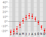
|
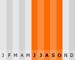
|
Typisch
| Officiële landsnaam | Canada |
| Hoofdstad | Ottowata |
| Nationaliteit | Canadees |
| Talen | frans, engels |
| Visum nodig? | Nee |
| Munteenheid | Canadese Dollar (CAD) |
| Regeringsvorm | constitutionele monarchie |
| Grootte t.o.v. Nederland | 240.4 keer groter |
| Bevolking | 33.2 miljoen |
| Bevolkingsdichtheid t.o.v. Nederland | 120.5 keer lager |
| Laagste punt | 0 m |
| Hoogste punt | 5959 m |
Tags
outdoor meren Bergen Zee en strand steppe subpoolklimaat zeeklimaat landklimaat bergklimaat Wintersport Duiken KamperenLow-cost airlines
- Air Berlin
Interessante boeken over Canada
-
Wegenkaart landkaart 583 Northeastern USA, Eastern Canada | Michelin | 8.95 €
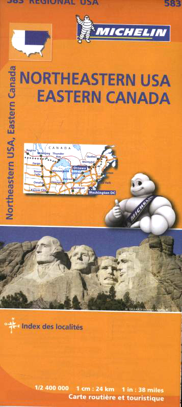
Wegenkaart van het noordoostelijke gedeelte van de USA (Kansas City - Fargo - Boston - Washington DC) en zuidoost Canada (Québec - Montr&eacu... meer
Wegenkaart van het noordoostelijke gedeelte van de USA (Kansas City - Fargo - Boston - Washington DC) en zuidoost Canada (Québec - Montréal - Ottawa - Winnipeg - Regina). Zie uitsnede op de voorkant van de kaart.
Primary & secondary road networks are clearly marked out with indications of the number of lanes, intermediate distances and various possible road obstacles or things you should know including steep hills, height limits, toll barriers, prohibited roads and roads subject to restrictions.The map also includes small insets with street plans of the regions major towns, showing road names, one way streets and various places of interest (tourist sights, hospitals, parking, railway stations, etc.). Scenic routes on the map are marked out in green and an extensive index of place names is included.The map also features:Administrative boundariesRailways, Airports and Ferry ServicesImportant sights such as castles, ruins, and churchesDriving Times and Distance ChartsRoad Safety InformationA legend in multiple languages, including English -
Plattegrond Vancouver Popoutmap | Footprint | 8.25 €
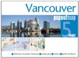
Vancouver popout map is a portable, comprehensive, and multipart map to this Canadian city. Complete with easy-to-read color maps, this pocket-size ... meer
Vancouver popout map is a portable, comprehensive, and multipart map to this Canadian city. Complete with easy-to-read color maps, this pocket-size guide includes at-a-glance travel information. The PopOut maps detail greater and downtown Vancouver; three smaller maps provide overviews of Stanley Park, the area aroud Vancouver Island, and Victoria/Vancouver. Details show places of interest, historic sites, shopping, parks, and more.
Vluchten naar Canada
-

Amsterdam naar Toronto-Ontario vanaf 423.88 €
-
Amsterdam naar Calgary-Alberta vanaf 502.77 €
Vakantiebestemmingen met vergelijkbare kenmerkenMisschien bent u ook geïnteresseerd in andere vakantielanden met de volgende kenmerken: |
Reis en Vakantie Top 10Canada is vertegenwoordigd in de volgende reis top10's:
|

- © 2010-2015 top10gezien.nl
- over deze site
- disclaimer
- adverteren
- contact