Highlights van China
Natuur
- Tain San Natuurpark - duizendjarige bomen in een landschap van granietrotsen
- Wolong nationaal Park - panda's in overvloed in dit begroeide berglandschap
- Shilin - bizarre kalksteenformaties vormen het décor van dit natuurgeweld


Cultuur
- Chinese muur - hoewel met zijn bijna 7000 kilometer lengte een indrukwekkend bouwwerk is de Chinese muur niet vanaf de maan te zien zoals sommigen beweren
- Verboden stad - eeuwenlang de thuisbasis van de Keizers
Overige mooiste bezienswaardigheden, evenementen, activiteiten en attracties
- Macau Tower Sky Jump - de hoogste bungeejump ter wereld (233 meter)
- De Tijgersprongkloof - een van de diepste canyons ter wereld
World Heritage Sites
- De Chinese Muur
- De berg Taishan
- Keizerlijke Paleizen van de Ming- en Qing-dynastieën
- Mogaogrotten nabij Dunhuang
- Mausoleum van de eerste Qin-keizer
- Vindplaats van de Pekingmens te Zhoukoudian
- De berg Huangshan
- Jiuzhaigou-vallei
- Huanglong
- Wulingyuan
- Bergresidentie en de buiten tempels van Chengde Tempel en begraafplaats van Confucius en het huis van de familie Kong in Qufu
- Het oude gebouwencomplex in de Wudang Bergen
- Potala Paleis - de Jokhang en het Norbulingka Paleis & Lhasa Nationaal park Lushan
- De heilige berg Emei inclusief de Grote Boeddha van Leshan
- Het oude stadje Lijiang
- De oude stad Ping Yao
- De klassieke tuinen van Suzhou
- Het Zomerpaleis - een keizerlijke tuin in Peking
- De Tempel van de hemel - een keizerlijk offeraltaar in Peking
- De berg Wuyi
- De rotsgraveringen van Dazu
- De berg Qingcheng en het Dujiangyan-irrigatiesysteem
- Oude dorpen van zuidelijk Anhui - Xidi en Hongcun
- De grotten van Longmen
- De Keizerlijke graven van de Ming- en Qing-dynastieën
- De grotten van Yungang
- De beschermde gebieden binnen de drie parallelle rivieren van Yunnan
- Hoofdsteden en graven van het Koguryorijk
- Macau
- Yin Xu
- Reservaten van de reuzenpanda in Sichuan
- Kaiping Diaolou en dorpjes
- Het Zuid-Chinese karstlandschap

Typisch
| nationale gerechten | mantou |
| nationale dranken | Chinese thee |
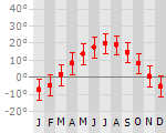
Klimaat
| Kenmerken |
|
| Temperatuur | Beste tijd voor een reis |
|

|
Typisch
| Officiële landsnaam | Volksrepubliek China |
| Hoofdstad | Peking |
| Nationaliteit | Chinees |
| Talen | Chinees Mandarin, Chinees, Wu, Chinees, Yue |
| Visum nodig? | Ja |
| Munteenheid | Yuan (CNY) |
| Regeringsvorm | communistisch |
| Grootte t.o.v. Nederland | 231.1 keer groter |
| Bevolking | 1330.0 miljoen |
| Bevolkingsdichtheid t.o.v. Nederland | 2.9 keer lager |
| Laagste punt | -154 m |
| Hoogste punt | 8850 m |
Tags
Bergen Zee en strand tropisch steppe woestijn subtropisch landklimaat bergklimaat Wintersport BackpackenExotische ziekten
- rabies
- malaria
- hepatitis A
- typhus
- leptospirosis
- Japanese encephalitis
Interessante boeken over China
-
Reisgids Dominicus China | Dominicus | 29.95 €
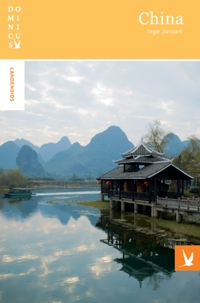
Rijk geillustreerde gids met nadruk op historische en culturele hoogtepunten. Daarnaast nog veel besprekingen van toeristische plaatsen. Zonder meer... meer
Rijk geillustreerde gids met nadruk op historische en culturele hoogtepunten. Daarnaast nog veel besprekingen van toeristische plaatsen. Zonder meer een complete gids met in deze nieuwe editie aandacht voor landschap en natuur. Met veel foto’s is het een lust voor het oog.
Een zeer uitgestrekt land met een grote diversiteit aan landschappen, klimaat en leefwijzen.
• Uitgebreide achtergrondinformatie over de belangrijkste regio's en steden, met alle bezienswaardigheden.
• Deze gids is een leidraad voor iedereen die dit immense land gaat bereizen.'Een reis van duizend mijl begint met een enkele stap,' zei de taoïstische filosoof Lao Zi zo'n 2500 jaar geleden. Voor iemand die naar China met vakantie gaat, geldt min of meer het 'omgekeerde': wie zijn eerste stap in China zet, zal een reis van duizenden mijlen afleggen.
China is een buitengewoon uitgestrekt land en kent daardoor een grote diversiteit, in landschap en klimaat, maar ook in levenswijze van de bewoners. Voordat een reiziger eraan toekomt de verschillende gezichten van China te onderscheiden, zijn er talrijke andere attractieve facetten te ontdekken.
De meeste reizigers maken kennis met China in de miljoenenstad Beijing, dus met drommen mensen, chaotisch verkeer, indringende geuren, onleesbare borden en onverstaanbare gesprekken. Je voelt je vaak een vreemdeling en een analfabeet tegelijk. Op die momenten heb je behoefte aan een gids. En dat is precies wat dit boek wil zijn: een leidraad voor iedereen die dit immense land gaat bereizen.
De eerste vijf hoofdstukken bevatten uitgebreide achtergrondinformatie en vervolgens worden de belangrijkste regio's en steden met alle bezienswaardigheden (waarvan de namen tevens in Chinese karakters zijn vermeld) behandeld. Uitstekende kaarten en plattegronden, bijzonder mooie foto's en uitgebreide praktische informatie completeren het geheel.
-
Reisgids Navigator China | ANWB | 24.95 €

De Navigator reisgidsen zijn luxe uitgevoerde gidsen, boordevol informatie. ANWB Navigator combineert een glossy uitstraling met een grote toegankeli... meer
De Navigator reisgidsen zijn luxe uitgevoerde gidsen, boordevol informatie.
ANWB Navigator combineert een glossy uitstraling met een grote toegankelijkheid. Naast traditionele onderwerpen als geschiedenis en bezienswaardigheden biedt ANWB Navigator u nog veel meer.
Bijvoorbeeld informatie over shoppen, hoe het openbaar vervoer werkt, foto’s van restaurants en hotels, locatiekaartjes per hoofdstuk, tips voor internetsites en leuke artikelen over ‘het leven in ..’- Hoofdstuk met wandel- en autoroutes
- Heldere atlas en kaartcoördinaten
- Plastic tabs zorgen voor groot gebruiksgemak


Reis en Vakantie Top 10China is vertegenwoordigd in de volgende reis top10's:
|

- © 2010-2015 top10gezien.nl
- over deze site
- disclaimer
- adverteren
- contact