Highlights van India
Natuur
- Kaziranga National Park - reservaat waar de met uitsterven bedreigde neushoorn wordt beschermd


Cultuur
- Taj Mahal - de perfecte architectuur van dit marmeren mausoleum zie je als gedurende de dag dit bouwwerk langzaam van kleur verandert
World Heritage Sites
- Grotten van Ajanta
- Grotten van Ellora
- Fort van Agra
- Taj Mahal
- Zonnetempel van Konarak
- Groep monumenten bij Mahabalipuram
- Nationaal park Kaziranga
- Wildpark Manas (wildpark)
- Nationaal park Keoladeo
- Kerken en kloosters van Goa
- Monumentengroep bij Khajuraho
- Monumentengroep bij Hampi
- Fatehpur Sikri
- Monumentengroep bij Pattadakal
- Grotten van Elephanta
- Chola-tempels
- Nationaal park Sundarbans
- Nationaal Park Bloemenvallei (uitbreiding van Nanda Devi) Boeddhistische monumenten bij Sanchi
- Humayun's tombe (Delhi)
- Qutb Minar en zijn monumenten (Delhi)
- Bergspoorwegen in India en de Darjeelingspoorweg
- Mahabodi tempelcomplex in Bodh Gaya
- Rots-schuilplaatsen van Bhimbetka
- Archeologisch park Champaner-Pavagadh
- Het station Chhatrapati Shivaji Terminus
- Het Rode Fortcomplex

Typisch
| nationale gerechten | Thali |
| nationale dranken | Lassi, Chai |
Klimaat
| Kenmerken |
|
| Temperatuur | Beste tijd voor een reis |
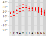
|
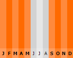
|
Typisch
| Officiële landsnaam | Republiek India |
| Hoofdstad | New Delhi |
| Nationaliteit | Indier |
| Talen | overig, engels, hindi |
| Visum nodig? | Ja |
| Munteenheid | Indiase Rupee (INR) |
| Regeringsvorm | federale republiek |
| Grootte t.o.v. Nederland | 79.2 keer groter |
| Bevolking | 1148.0 miljoen |
| Bevolkingsdichtheid t.o.v. Nederland | 1.1 keer lager |
| Laagste punt | 0 m |
| Hoogste punt | 8598 m |
Tags
tropisch moesson woestijn steppe subtropisch bergklimaat Wintersport Duiken Backpacken regenseizoen Bergen Zee en strandExotische ziekten
- Chikungunya-virus
- rabies
- malaria
- hepatitis A
- typhus
- dengue
- Japanese encephalitis
Interessante boeken over India
-
Reisgids Rough Guide Goa | Rough Guide | 18.50 €
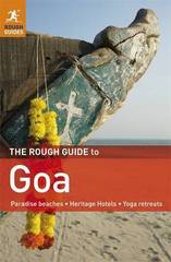
Zeer goede reisgids voor zowel de georganiseerde maar vooral voor de zelfstandige reiziger. Boordevol informatie over reizen, slapen, eten, maar ook m... meer
Zeer goede reisgids voor zowel de georganiseerde maar vooral voor de zelfstandige reiziger. Boordevol informatie over reizen, slapen, eten, maar ook musea en cultuur. Voor de meeste landen meestal completer en beter dan de Lonely Planet !
"The Rough Guide to Goa" will guide you through this colourful former Portuguese colony with reliable, practical information and clearly explained cultural background. You'll find detailed accounts of every major tourist sight, along with candid reviews of all the best places to sleep, eat, drink and shop, for all budgets. "The Rough Guide to Goa" includes first-hand coverage of the region's resorts, beaches, markets, monuments, temples and wildlife sanctuaries, as well as its more offbeat sights; from prehistoric rock carvings deep in the forest to colonial-era mansions. The full-colour introduction and inserts, along with inspirational photography, give you a flavour of this region's Portuguese legacy. Make the most of your trip with "The Rough Guide to Goa". -
Het Nirwana is een lege trein | Michiel van Kempen | M. Van Kempen 14.50 €
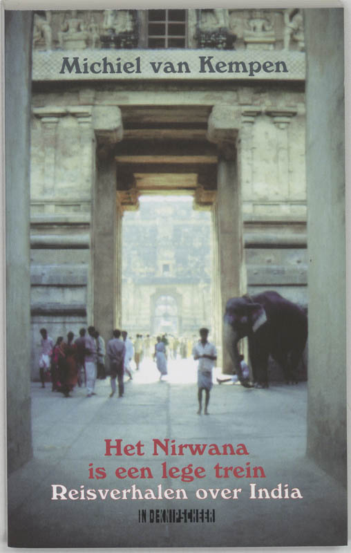
Verslag van de ervaringen opgedaan tijdens een reis door India. In India is alles in veelvoud aanwezig: talen, religies, monumenten en mense... meer
Verslag van de ervaringen opgedaan tijdens een reis door India.
In India is alles in veelvoud aanwezig: talen, religies, monumenten en mensen - alleen al in Bombay 15 miljoen. Temidden van deze chaos houdt Michiel van Kempen het hoofd koel en observeert, opdat de lezer inzicht krijgt in 'de kronkeligehersens van de Ganges'. En daarbij komt zijn kennis van het Hindi (als taalwetenschapper over Suriname) goed van pas: 'Het is prettig dat we kunnen verstaan hoe ze een stroom van denigrerend commentaar in het Hindi over ons uitstorten'.

Reis en Vakantie Top 10India is vertegenwoordigd in de volgende reis top10's:
|

- © 2010-2015 top10gezien.nl
- over deze site
- disclaimer
- adverteren
- contact