Highlights van Japan
Natuur
- Kushiro Nationaal Park - de kraanvogel leeft hier in de veelkleurige omgeving van moerassen en veengebieden


Cultuur
- Het Kasteel Hime-ji - het Kasteel van de witte reiger
- Vliegveld Kansai - een luchthaven gebouwd op zee
World Heritage Sites
- Boeddhistische monumenten in het Horyuji-gebied
- Kasteel Himeji
- Yakushima
- Shirakami Sanchi
- Historische monumenten van oud-Kioto (Kioto & Uji en Otsu)
- Historische dorpen van Shirakawago en Gokayama
- Vredesmonument van Hiroshima (Genbaku Dome)
- Itsukushima-schrijn
- Historische monumenten van oud-Nara
- Schrijnen en tempels van Nikko
- Gusuku-locatie en gerelateerde plaatsen van het Koninkrijk Riukiu
- Drie heilige plaatsen en de pelgrimsroute in het Kii-gebergte
- Shiretoko
- Zilvermijn Iwami Ginzan en zijn cultuurlandschap

Typisch
| nationale gerechten | sushi en sashimi |
| nationale dranken | sake |
Klimaat
| Kenmerken |
|
| Temperatuur | Beste tijd voor een reis |
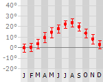
|
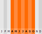
|
Typisch
| Officiële landsnaam | Japan |
| Hoofdstad | Tokyo |
| Nationaliteit | Japanner |
| Talen | overig |
| Visum nodig? | Nee |
| Munteenheid | Yen (JPY) |
| Regeringsvorm | constitutionele monarchie |
| Grootte t.o.v. Nederland | 9.1 keer groter |
| Bevolking | 127.3 miljoen |
| Bevolkingsdichtheid t.o.v. Nederland | 1.2 keer lager |
| Laagste punt | -4 m |
| Hoogste punt | 3776 m |
Interessante boeken over Japan
-
Reisgids Japan by Rail | Trailblazer | 22.50 €
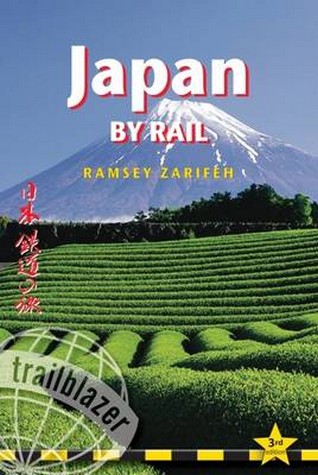
Treinreis handboek van Japan, met beschrijvingen en praktische informatie over alle belangrijke spoorwegen en de steden onderweg, dwars doo... meer
Treinreis handboek van Japan, met beschrijvingen en praktische informatie over alle belangrijke spoorwegen en de steden onderweg, dwars door Japan (treinreizen)Japan is steeped in legend and myth, perhaps the greatest of which is the popular misconception that the country is simply too expensive to visit. The truth is that flights to Japan are cheaper than they've ever been, accommodation can be great value, while the warm hospitality which awaits every visitor costs nothing at all. The real secret to travelling around the country on a budget, however, is the Japan Rail Pass. With this pass you can travel on some of the fastest trains in the world as often as you like for as long as you please - and all for one bargain price. Use this comprehensive guide in conjunction with a rail pass to get the most out of your trip to Japan.- Practical information Planning your trip; what to take; getting to Japan from Europe, North America and Australasia- City guides and maps Where to stay (all budgets), where to eat, what to see in 29 towns and cities; historical and cultural background- Kilometre-by-kilometre route guides Covering train journeys from the coast into the mountains, from temple retreat to sprawling metropolis and from sulphurous volcano to windswept desert; 34 route maps- Railway timetables Bullet trains and all routes in this guidebook- Plus Customs, etiquette, Japanese phrases and 28 colour photos -
Reisverhaal Het verrukkend wonderlijke en verdervend rampzalige | Valkhof Pers | Marjolijn Steenveld 12.95 €
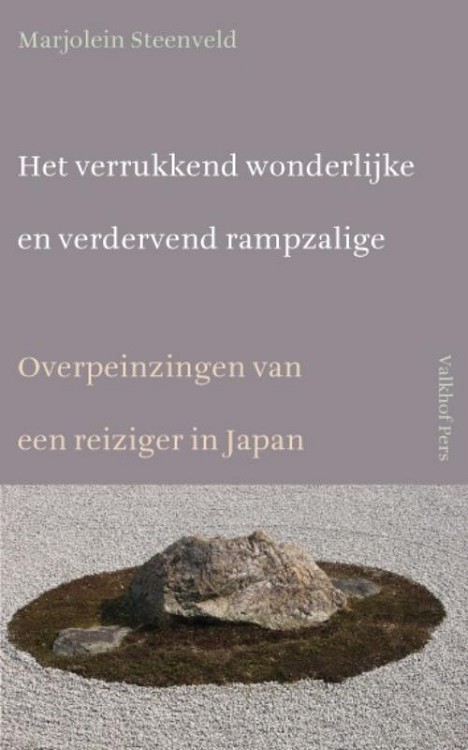
Overpeinzingen van een reiziger in Japan. ‘Vandaag overwin ik mijn zelf van gisteren. Dat is Chadõ, de weg van de thee&rsquo... meer
Overpeinzingen van een reiziger in Japan.
‘Vandaag overwin ik mijn zelf van gisteren. Dat is Chadõ, de weg van de thee’
Japan, land van tegenstellingen en paradoxen. Marjolein Steenveld reisde per fiets door geheimzinnig en fascinerend Japan. Van Hiroshima langs de Japanse Binnenzee naar het eiland Shikoku met zijn 88 tempels, naar de berg Koya San en steden als Kobe en Kyoto, om uiteindelijk te eindigen in Tokyo. De schrijfster verwondert zich over de tegenstrijdige cultuuruitingen van Japan waar superconsumentisme en oeroude waarden als Wabi Sabi, de schoonheid van eenvoud, terughoudendheid en elegantie, naast elkaar bestaan.
Het verrukkend wonderlijke en verdervend rampzalige beschrijft niet alleen een geografische maar vooral ook een mentale reis. De zoektocht naar de betekenis van de Ryoanji Zentuin in Kyoto loopt daarbij als een rode draad door de verschillende verhalen. Het boek geeft niet alleen inzicht in de betekenis van Japanse cultuuruitingen als kalligrafie, tuinkunst en theeceremonie, maar beschrijft ook het verschil tussen de oosterse en westerse manier van omgaan met tegenstellingen, het voorbijgaande en onvolmaakte. De lezer reist niet alleen door Japan maar ook door de wereld van Zen.
‘...zou de man nu ook die zachte droefheid voelen, het Mono no Aware?’
Van Marjolein Steenveld verscheen eerder Fietsen naar Rome met Marcus Aureliuswaarvoor de auteur veel lof ontving in de pers:
‘Marjolein Steenveld hanteert een beschaafde en beheerste pen, met fijngevoelige observaties van natuur, landschap en mensen. (...) De combinatie van begaafde schrijfstijl met toepasselijke wijsheden geeft dit boekje het extra gewicht, waarmee het kwalitatief ver boven een gemiddeld fietsreisboek uitstijgt. Marjolein Steenveld levert hiermee tevens het bewijs dat lichtvoetigheid goed samen kan gaan met diepgang’ – de Wereldfietser

Vakantiebestemmingen met vergelijkbare kenmerkenMisschien bent u ook geïnteresseerd in andere vakantielanden met de volgende kenmerken: |
Reis en Vakantie Top 10Japan is vertegenwoordigd in de volgende reis top10's:
|

- © 2010-2015 top10gezien.nl
- over deze site
- disclaimer
- adverteren
- contact