Highlights van Kirgizië


World Heritage Sites
- geen

Typisch
| nationale gerechten | laghman |
Klimaat
| Kenmerken |
|
| Temperatuur | Beste tijd voor een reis |
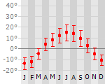
|
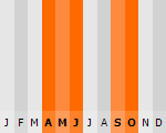
|
Typisch
| Officiële landsnaam | Kirgizische Republiek |
| Hoofdstad | Bishkek |
| Nationaliteit | Kirgies |
| Talen | overig, russisch |
| Visum nodig? | Ja |
| Munteenheid | Som (KGS) |
| Regeringsvorm | republiek |
| Grootte t.o.v. Nederland | 4.8 keer groter |
| Bevolking | 5.4 miljoen |
| Bevolkingsdichtheid t.o.v. Nederland | 14.9 keer lager |
| Laagste punt | 132 m |
| Hoogste punt | 7439 m |
Interessante boeken over Kirgizië
-
Reisgids Kyrgyz Republic - Kyrgizië | Odyssey Books & Guides | 23.75 €
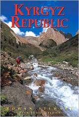
Kyrgyz Republic Kyrgyzstan: Heart of Central Asia - Odyssey Publications (Kirgizië/Kirgizstan) De Odyssey reisgids is een degelijke Engelstali... meer
Kyrgyz Republic Kyrgyzstan: Heart of Central Asia - Odyssey Publications (Kirgizië/Kirgizstan)
De Odyssey reisgids is een degelijke Engelstalige gids met achtergrondinformatie over cultuur en populatie, praktische informatie, hints voor de bezoeker, openbaar vervoer, accommodaties, foto’s en kaarten.This unique and stunningly illustrated book, the first English-language guide exclusively dedicated to Kyrgyzstan, provides up-to-date practical information on the full range of travel possibilities to all parts of the country, along with a clear overview of the historical, cultural and social context to help in understanding this complex country. Kyrgyzstan’s mighty Tien Shan mountains formed the Soviet Empire’s impressive border with China and helped to keep this small land impenetrable to visitors. Opened to the world just ten years ago, Kyrgyzstan offers a rich history and ancient, hospitable cultures, as well as tremendous scenic beauty and diversity.
-
Wegenkaart - Autokaart - Landkaart Aksu ( China, Kyrgyzstan ) | EWP | 16.25 €
.jpg)
Mooie, gedetailleerde topografische kaart van het Westen van Kirgizië. Met hoogtelijnen.
Mooie, gedetailleerde topografische kaart van het Westen van Kirgizië. Met hoogtelijnen.
Reis en Vakantie Top 10Kirgizië is vertegenwoordigd in de volgende reis top10's:
|

- © 2010-2015 top10gezien.nl
- over deze site
- disclaimer
- adverteren
- contact