Highlights van Nepal


World Heritage Sites
- Nationaal park Sagarmatha
- De Kathmandu-vallei Nationaal park Royal Chitwan
- Lumbini
- de geboorteplaats van de Boeddha

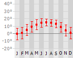
Klimaat
| Kenmerken |
|
| Temperatuur | Beste tijd voor een reis |
|

|
Typisch
| Officiële landsnaam | Koninkrijk Nepal |
| Hoofdstad | Kathmandu |
| Nationaliteit | Nepalees |
| Talen | overig |
| Visum nodig? | Ja |
| Munteenheid | Nepali Rupee (NPR) |
| Regeringsvorm | democratische republiek |
| Grootte t.o.v. Nederland | 3.5 keer groter |
| Bevolking | 29.5 miljoen |
| Bevolkingsdichtheid t.o.v. Nederland | 2.0 keer lager |
| Laagste punt | 70 m |
| Hoogste punt | 8850 m |
Low-cost airlines
- Arke Fly
Exotische ziekten
- malaria
- hepatitis A
- typhus
- Japanese encephalitis
Interessante boeken over Nepal
-
Wandelkaart Nepal 10 Jumla - Rara Lake 1:100.000 | Schneider | 13.75 €
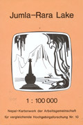
Goede wandelkaart van een deel van Nepal. Ze worden beschouwd als een van de betere kaartenseries van Nepal. Met topografische details als hoogtelijne... meer
Goede wandelkaart van een deel van Nepal. Ze worden beschouwd als een van de betere kaartenseries van Nepal. Met topografische details als hoogtelijnen, een mooi kleurgebruik en deels - de meer bekende zeker - ingetekende trekkingroutes. Ze zijn niet altijd van zeer recente datum, maar nog altijd uitstekend bruikbaar in deze nauwelijks veranderende berggebieden!
-
Reisgids Nepal | Rough Guide (Nederlandstalig) | 24.99 €
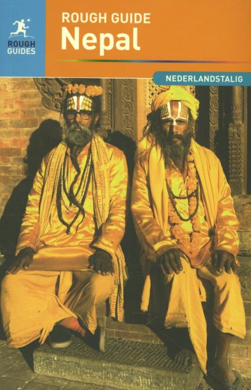
Zeer goede reisgids voor zowel de georganiseerde maar vooral voor de zelfstandige reiziger. Boordevol informatie over reizen, slapen, eten, maar ook... meer
Zeer goede reisgids voor zowel de georganiseerde maar vooral voor de zelfstandige reiziger. Boordevol informatie over reizen, slapen, eten, maar ook musea en cultuur. Voor veel landen meestal completer en beter dan de Lonely Planet. Vertaling van de Engelse editie.
Wie aan Nepal denkt, denkt aan bergen, heel hoge bergen. In dit kleine land, ingeklemd tussen India en China, ligt inderdaad het hoogste en meest ruige deel van de Himalaya. Het land heeft echter veel meer te bieden: oude hindoetempels, weelderige boeddhistische kloosters, liefelijke heuvels, eeuwenoude festivals, maar ook onverwacht relaxte bars. Deze Rough Guide laat het veelzijdige gezicht van Nepal zien en bevat tevens hoofdstukken over trekking, raften en mountainbiken.
"The Rough Guide to Nepal" is the ultimate travel guide with clear maps and detailed coverage of all the best attractions Nepal has to offer. Discover the vibrant regions of Nepal from the easternmost tea hills of Ilam to the wildlife-rich jungle of the far west, and from the high Himalayas to the Kathmandu Valley. Fully updated and reshaped after the country's recent change in government, "The Rough Guide to Nepal" contains in-depth accounts of all Nepal's highlights from Hindu temples and Buddhist stupas to wildlife reserves and spectacular mountain viewpoints in Nepal. Colour sections explore Nepal's ethnic hill people and dramatic mountain trails whilst expert accounts offer an introduction to the history, culture and natural life of this exciting and resurgent country. Find detailed practical advice on what to see and do in Nepal whilst relying on up-to-date descriptions of the best hotels in Nepal, bars in Nepal and restaurants in Nepal for every budget. "This Rough Guide to Nepal" includes an extensive section on trekking with practical advice and maps on the best places to trek, raft and mountain bike. Make the most of your holiday with "The Rough Guide to Nepal".
Reis en Vakantie Top 10Nepal is vertegenwoordigd in de volgende reis top10's:
|

- © 2010-2015 top10gezien.nl
- over deze site
- disclaimer
- adverteren
- contact