Highlights van Tadzjikistan


World Heritage Sites
- geen

Typisch
| nationale gerechten | Qurutob |
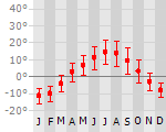
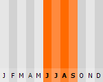
Klimaat
| Kenmerken |
|
| Temperatuur | Beste tijd voor een reis |
|
|
Typisch
| Officiële landsnaam | Republiek Tadzjikistan |
| Hoofdstad | Dushanbe |
| Nationaliteit | Tadzjiek |
| Talen | overig, russisch |
| Visum nodig? | Ja |
| Munteenheid | Somoni (TJS) |
| Regeringsvorm | republiek |
| Grootte t.o.v. Nederland | 3.4 keer groter |
| Bevolking | 7.2 miljoen |
| Bevolkingsdichtheid t.o.v. Nederland | 8.0 keer lager |
| Laagste punt | 300 m |
| Hoogste punt | 7495 m |
Exotische ziekten
- malaria
- hepatitis A
- typhus
Interessante boeken over Tadzjikistan
-
Wegenkaart - Autokaart - Landkaart The Pamirs | Gecko Maps | 16.95 €
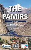
The map "The Pamirs" was done in several years work by the swiss cartographer Markus Hauser for the UNESCO projekt "Cultural and Eco-tourism in the Mo... meer
The map "The Pamirs" was done in several years work by the swiss cartographer Markus Hauser for the UNESCO projekt "Cultural and Eco-tourism in the Mountainous Regions of Central Asia and in the Himalaya". In Tajikistan the Projekt is implemented by the french NGO ACTED.
Tajikistan is a land of majestic peaks, glaciers, and high mountain deserts. The country with its rich cultural heritage and diverse landscapes is still waiting to be discovered. Tourism is hardly developed – and thus, many a mystery remains to be uncovered by those willing to venture into the country. The Pamirs, the mountain range covering the Eastern part of Tajikistan - administratively known as ‘Gorno Badakhshan’ since Soviet times – are particularly remote and have had a special status due to their geographic location. Simultaneously, they are amongst the pearls in the crown of the world’s high mountain ranges.
This map represents a key to the discovery of that mythical region. It’ll help you to trace your way along the historical paths of the high Silk Road, the deep cut valleys of the west and the vast plains of the high plateau of the Eastern part of the region. It’ll equip you with relevant travel information for a unique experience of breathtaking landscapes and of diverse cultures united by the celebration of hospitality.
-
Reisgids Tadschikistan - Tadzjikistan | Treschjer Verlag | 19.95 €
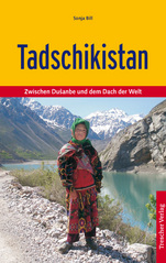
Goede Duitstalige reisgids over een nauwelijks bezocht Tadzjikistan. Veel beschrijvingen van cultuur, bevolking en bezienswaardigheden. Daarnaast ook... meer
Goede Duitstalige reisgids over een nauwelijks bezocht Tadzjikistan. Veel beschrijvingen van cultuur, bevolking en bezienswaardigheden. Daarnaast ook praktische informatie. (Duitstalig)
Tadschikistan wird auch gerne die ›Schweiz Zentralasiens‹ genannt. Vor allem die Hochgebirgsregionen des Alai und des Pamir locken mit vielfältigen Reiseerlebnissen: Eine Fahrt auf dem Pamirhighway über das Dach der Welt, ein Bad in heißen Quellen, Beobachtung seltener Wildtiere, eine Kameltour entlang der alten Seidenstraße oder eine Wanderung vorbei an türkisen Seen und Berggiganten, das sind nur einige der Möglichkeiten in diesem bisher noch eher unbekannten Reiseland.
Auch kulturell hat das kleine Land viel zu bieten. So kann man auf den Spuren vorchristlicher Kulturen, des Buddhismus und des Islam reisen. In den Fußstapfen Marco Polos trifft der Reisende überall auf herzliche Gastfreundschaft und ein kleines Abenteuer.
Dieser Reiseführer gibt zahlreiche Hinweise zur Vorbereitung einer unvergesslichen Reise. Tipps zu Unterkünften, Routen und Reisemöglichkeiten imd ermöglichen einen besonderen und individuellen Aufenthalt. Ausführliche Informationen zu Geschichte und Lebensweise bieten einen Einblick in die tadschikische Kultur.
Reis en Vakantie Top 10Tadzjikistan is vertegenwoordigd in de volgende reis top10's:
|

- © 2010-2015 top10gezien.nl
- over deze site
- disclaimer
- adverteren
- contact