Highlights van Thailand


Cultuur
- Koninklijk paleis (Bangkok) - veelheid aan gebouwen en tempels waar ook nu de koning nog woont
World Heritage Sites
- De historisch stad Sukhothai en omgeving
- De historische stad Ayutthaya en omgeving
- Wildpark Thungyai Huai Kha Khaeng
- Archeologische plaats Ban Chiang
- Dong Phayayen

Typisch
| nationale gerechten | Pad Thai |
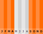
Klimaat
| Kenmerken |
|
| Temperatuur | Beste tijd voor een reis |
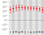
|
|
Typisch
| Officiële landsnaam | Koninkrijk Thailand |
| Hoofdstad | Bankok |
| Nationaliteit | Thailander |
| Talen | overig |
| Visum nodig? | Nee |
| Munteenheid | Baht (THB) |
| Regeringsvorm | constitutionele monarchie |
| Grootte t.o.v. Nederland | 12.4 keer groter |
| Bevolking | 65.5 miljoen |
| Bevolkingsdichtheid t.o.v. Nederland | 3.1 keer lager |
| Laagste punt | 0 m |
| Hoogste punt | 2576 m |
Low-cost airlines
- Air Berlin
Don't do this
- Fullmoonparty. Zo 2008...
Exotische ziekten
- rabies
- malaria
- hepatitis A
- dengue
- leptospirosis
- Japanese encephalitis
Interessante boeken over Thailand
-
Landkaart - wegenkaart Ko Samui and Southern Thailand | Globetrotter | 10.25 €
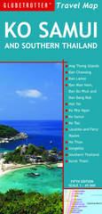
Goede overzichtskaart van het zuiden van Thailand met een gedetailleerde kaart van Ko Samui, klein register en aanvullende toeristische info.
Goede overzichtskaart van het zuiden van Thailand met een gedetailleerde kaart van Ko Samui, klein register en aanvullende toeristische info.
-
Reisgids Thailand | Kit Landenreeks | 14.50 €

De gidsen van Landenreeks, van het Koninklijk Instituut voor de Tropen en Novib, geven met name goede achtergrondinformatie op het gebied van Geschied... meer
De gidsen van Landenreeks, van het Koninklijk Instituut voor de Tropen en Novib, geven met name goede achtergrondinformatie op het gebied van Geschiedenis, Politiek, Economie, Religie, Samenleving, Cultuur en Milieu van het land.
Sjon Hauser vestigde zich in 1983 in Thailand als journalist in Chiang Mai. Hij schreef enkele reisgidsen en journalistieke werken over de Thaise samenleving.
Vakantiebestemmingen met vergelijkbare kenmerkenMisschien bent u ook geïnteresseerd in andere vakantielanden met de volgende kenmerken: |
Reis en Vakantie Top 10Thailand is vertegenwoordigd in de volgende reis top10's:
|

- © 2010-2015 top10gezien.nl
- over deze site
- disclaimer
- adverteren
- contact