Highlights van Turkije
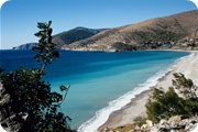
Turkije is een land waar Europa en Azië elkaar letterlijk ontmoeten, en dat is direct te voelen in Istanbul, waar minaretten en moderne wolkenkrabbers samen de skyline vormen. Het land biedt een indrukwekkende variatie: van de bruisende bazaars en Byzantijnse monumenten van Istanbul, via de maanlandschapachtige rotsformaties en ballonvaarten van Cappadocië, tot de zonovergoten Turkse Rivièra met haar heldere baaien en antieke ruïnes zoals Efeze en Troje. Turkije heeft een van de langste geschiedenissen ter wereld en dat is overal zichtbaar, van Ottomaanse paleizen tot Griekse en Romeinse tempels. Tegelijk is het een land met een warme gastvrijheid, uitgebreide theecultuur en een keuken die veel verder gaat dan de bekende kebab. Turkije is een geschikte bestemming voor cultuurliefhebbers die geschiedenis en architectuur willen combineren met een ontspannen strandvakantie, voor actieve reizigers die willen wandelen, duiken of paragliden, en voor wie op zoek is naar een betaalbare all-inclusive vakantie aan zee. Ook voor stedentrips is Istanbul, met zijn unieke ligging en enorme culturele rijkdom, een aanrader. Door de omvang van het land en de grote regionale verschillen is er voor bijna elk type reiziger wel een passende hoek van Turkije te vinden.
Natuur
- Goreme nationaal park - een uitgestrekt park met bizarre rotsformaties van tufsteen


Cultuur
- Hagia Sophia - eens een kerk; nu een museum maar nog steeds imposant
Sport en avontuur
- Ballonvaren boven Cappadocië
- Paragliden vanaf de Babadağ bij Ölüdeniz
- Duiken en snorkelen langs de Turkse Rivièra
- Wandelen over de Lycische Weg
- Wintersport in Uludağ of Palandöken
- Wildwatervaren in de bergen bij de Zwarte Zeekust
World Heritage Sites
- Historische gebieden van Istanbul
- Nationaal park Göreme en de rotsen van Cappadocië
- Grote Moskee en Hospital van Divrigi
- Hattusha
- Nemrut Dagi
- Xanthos-Letoon
- Hierapolis Pamukkale
- De stad Safranbolu
- Archeologische plaats van Troje

Plan je reis naar Turkije
Dit zijn advertentielinks. Top10gezien kan een commissie ontvangen als je via deze links boekt.
Typisch
| nationale gerechten | doner kebab |
| nationale dranken | Raki |
| beroemd om | Turkse thee en Turkse koffie, Baklava en andere zoetigheden, Hamam (Turks bad), De Grand Bazaar in Istanbul, Ballonvaarten boven Cappadocië, Kebab en meze |
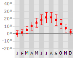
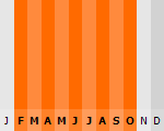
Klimaat
| Kenmerken |
|
| Temperatuur | Beste tijd voor een reis |
|
|
Typisch
| Officiële landsnaam | Republiek Turkije |
| Hoofdstad | Ankara |
| Nationaliteit | Turk |
| Talen | overig |
| Visum nodig? | Nee |
| Munteenheid | Turkse Lira (YTL) |
| Regeringsvorm | republiek |
| Grootte t.o.v. Nederland | 18.8 keer groter |
| Bevolking | 71.9 miljoen |
| Bevolkingsdichtheid t.o.v. Nederland | 4.4 keer lager |
| Laagste punt | 0 m |
| Hoogste punt | 5166 m |
Low-cost airlines
- Arke Fly
- Air Berlin
- Corendon
- Thomas Cook
- Sunexpress
- Pegasus Air
Don't do this
- Vermijd respectloze opmerkingen over Atatürk of gevoelige politieke onderwerpen
- Kleed je gepast bij bezoek aan moskeeën (schouders en benen bedekt, hoofddoek voor vrouwen)
- Drink geen kraanwater
- Onderhandel in de bazaars, maar blijf vriendelijk
- Wees alert op tapijtwinkels en gidsen met (te) gunstige aanbiedingen
- Houd rekening met terughoudendheid bij eten en drinken op straat tijdens de ramadan
Interessante boeken over Turkije
-
Wandelkaart Turkije - Turkey, the highest peaks | Terraquest | 19.25 €
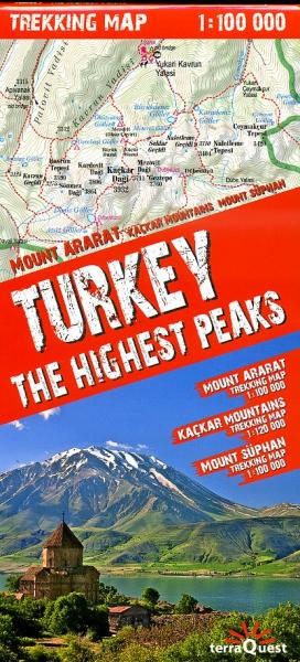
Geplastificeerde trekking map, goede cartografie, van de omgevingen van Mount Ararat, het Kaçkar massief en Mount Süphan (ten noorden va... meer
Geplastificeerde trekking map, goede cartografie, van de omgevingen van Mount Ararat, het Kaçkar massief en Mount Süphan (ten noorden van het meer van Van). Diverse routes ingetekend.
-
Reisgids Rough Guide Istanbul - Istanboel | Rough Guide | 20.50 €
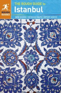
Net als de Lonely Planet en Footprint een echte gids voor de rugzakker. Veel info over slapen, vervoer en eten, maar ook aandacht voor algemene aspe... meer
Net als de Lonely Planet en Footprint een echte gids voor de rugzakker. Veel info over slapen, vervoer en eten, maar ook aandacht voor algemene aspecten van het land. Voor Europese steden naar onze mening net iets beter dan de Planet!
The Rough Guide to Istanbul is the perfect introduction to a vibrant mega-city, fast-becoming as popular for its nightlife and arts scene as it is for its unique historical heritage. All the major Byzantine and Ottoman sites, plus a myriad lesser-known gems, are easily tracked down using clear, comprehensive maps.Whether you wish to watch the faithful at prayer in the iconic Blue Mosque, admire the glittering gold mosaics in the Church of the Holy Wisdom, relax in an historic Turkish bath, cruise up the continent-dividing Bosphorus or dance the night away in an über-cool club, you can find out where and how in The Rough Guide to Istanbul. Evocative photographs of the city's highlights complement the text and two full-colour sections introduce the fascinating world of Ottoman Turkish architecture and the culinary delights of the Turkish kitchen.There are up-to-date descriptions of the city's best bars, cafes, clubs, hotels, restaurants and shops for all budgets, and a detailed section on 'out of town' trips including the legendary city of Troy and the former-Ottoman capitals of Bursa and Edirne.
Vakantiebestemmingen met vergelijkbare kenmerkenMisschien bent u ook geïnteresseerd in andere vakantielanden met de volgende kenmerken: |
Reis en Vakantie Top 10Turkije is vertegenwoordigd in de volgende reis top10's:
|
- © 2010-2026 top10gezien.nl
- over deze site
- disclaimer
- adverteren
- contact