Highlights van Argentinië

Argentinie heeft het allemaal: van mooie stranden, tot goed eten, een van de mooiste watervallen ter wereld, en bergen voor een actieve vakantie. Daarnaast is Argentinie goedkoop en als je van voetbal houdt, bezoek dan eens een wedstrijd!
Natuur
- Iguacu watervallen - volgens velen de mooiste waterval ter wereld
- Fitzroy - ruige granieten rotspunt in Patagonië
- Iberá - een moerassengebied met drijvende eilanden
- de Pantanal - moerassig grasland met het beste ‘wild life watching’ van het Zuid-amerikaanse vasteland
- Nieve Penitentes - rijen ijs-stalagmieten
- Nationaal Park Los Glaciares - gletsjer-walhalla met de Perito Morenogletsjer als onbetwiste highlight
- Nationaal Park - Torres del Paine - brute natuur in de overtreffende trap
- Tierra del Fuego - zuidelijkste eilanden archipel van Argentinië en einde van de wereld


Cultuur
- Cristo Redentor de los Andes - een monument hoog in de Andes op de grenspas (3800 meter) tussen Argentinië en Chili
- Nationale congres - Buenos Aires
- Biblioteca Nacional - Nationale bibliotheek
Sport en avontuur
- eco-toerisme in het Beagle Kanaal - avontuurlijk wandelen door het zuidelijkste kustbos van de wereld
- het beklimmen van de Fitzroy - alleen voor pro’s
- Het meren-district - het outdoor mekka van Argentinië
Overige mooiste bezienswaardigheden, evenementen, activiteiten en attracties
- Buenos Aires - wereldstad met Franse alure
- Ushuaia - de zuidelijkste stad ter wereld
- Le Parc Figueroa Alcorta - Torre Cavia - het grootste gebouw van Argentinië (173 meter)
World Heritage Sites
- Los Glaciares
- Jesuit Missies van de Guaranis: San Ignacio Mini/ Santa Ana/ Nuestra Señora de Loreto en Santa Maria Mayor
- Iguazu Nationaal Park Cueva de las Manos: Río Pinturas
- Península Valdés
- Ischigualasto / Talampaya Natural Parks
- Jesuit Block en Estancias of Córdoba
- Quebrada de Humahuaca

Klimaat
| Kenmerken |
|
| Temperatuur | Beste tijd voor een reis |
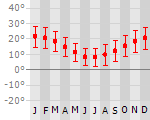
|

|
Typisch
| Officiële landsnaam | Republiek Argentinië |
| Hoofdstad | Buenos Aires |
| Nationaliteit | Argentijn |
| Talen | Spaans |
| Visum nodig? | Nee |
| Munteenheid | Argentijnse Peso (ARS) |
| Regeringsvorm | republiek |
| Grootte t.o.v. Nederland | 66.6 keer groter |
| Bevolking | 40.7 miljoen |
| Bevolkingsdichtheid t.o.v. Nederland | 27.3 keer lager |
| Laagste punt | -105 m |
| Hoogste punt | 6960 m |
Tags
Bergen Zee en strand tropisch steppe woestijn subtropisch zeeklimaat bergklimaat savanne Wintersport Duiken BackpackenDon't do this
- Het district La Boca - overgewaardeerde toeristenattractie in zuid Buenos Aires
Exotische ziekten
- hepatitis A
- leptospirosis
Interessante boeken over Argentinië
-
Reisgids Argentinien und Falkland Inseln | Dumont | 22.80 €
.jpg)
Haushohe Eiswände stürzen donnernd in den Lago Argentino im südlichen Patagonien, Stürme umtosen das berüchtigte Kap Hoorn vor den Toren der Antarktis... meer
Haushohe Eiswände stürzen donnernd in den Lago Argentino im südlichen Patagonien, Stürme umtosen das berüchtigte Kap Hoorn vor den Toren der Antarktis, im Sonnenuntergang glühen die schneebedeckten Gipfel der Andenkette. Gleichzeitig schwirren 3000 km weiter nördlich Kolibris im Wassernebel der Iguassu-Fälle durch dichtes Tropengrün. Schnurgerade Straßen durch die flache Pampa und die Einsamkeit des Chaco, Estancien, die bis hinter den Horizont reichen, aber auch quirliges Großstadtleben in der Millionenmetropole Buenos Aires und Städten wie Córdoba und Mendoza. Kein Land Südamerikas bietet dem Reisenden mehr Abwechslung, ist facettenreicher als Argentinien. Das DuMont-Reisehandbuch Richtig Reisen »Argentinien« ist ein optimaler zuverlässiger Begleiter, in dem die besten Touren und eine Fülle von Tipps für Aktivitäten und besondere Erlebnisse sowie zahlreiche Hintergrundinformationen kompakt zusammengefasst sind.
Den Autoren, Rolf Seeler, wohnhaft in Uruguay und Juan Garff, Deutschargentinier aus Buenos Aires, beides erfahrene Journalisten, ist das Land wie ihre Westentasche vertraut, und so wissen sie dem Reisenden die Schönheit und Vielfalt Argentiniens kenntnis- und detailreich zu vermitteln, seien es so bekannte Ziele wie die Halbinsel Valdés mit ihren Seeelefantenkolonien und vorbeiziehenden Walen, oder Ushuaia, die südlichste Stadt auf Feuerland, aber auch die entlegenen Regionen der Falklandinseln oder Iberá-Sümpfe, einzigartiges Feuchtbiotop im Zweistromland. Und natürlich haben sie jede Menge Tipps bereit, etwa eine urige Tango-Kneipe in Buenos Aires, einen fotogenen Blick auf den Cerro de los Siete Colores in Purmamarca oder einen Ausflug mit dem legendären Patagonien-Express.
Zu allen Städten, Regionen und herausragenden Sehenswürdigkeiten gibt es praktische Hinweise zu Öffnungszeiten und Anreisewegen sowie die Adressen der jeweiligen Tourismusbüros, empfehlenswerten Hotels, Restaurants mit den entsprechenden Internetlinks. Konzentriert in einem eigenen Kapitel sind wissenswerte Fakten für die Organisation und Gestaltung einer Argentinien-Reise, etwa zum Einkaufen und Ausgehen, zu sportlichen Aktivitäten sowie ein Sprachführer. Hinzu kommt Hintergrundwissen über Natur und Kultur, Geschichte und Politik in einem allgemeinen einführenden Teil. Ausgesprochen unterhaltsam zu lesen sind die eingestreuten Themenseiten: kurzweilige Storys über die Eigenarten und Besonderheiten des Reiseziels, u.a. über den skurrilsten Wallfahrtsort der Welt, die als »Straße der Tränen« bezeichnete Magellanstraße, und die rätselhafte Diaguita-Kultur. Für eine rasche Orientierung unterwegs sorgt das reichhaltige Kartenmaterial: zum einen ein vielseitiger, präziser Reiseatlas, zum anderen eine Fülle von regionalen Routenkarten.
Die brillanten Fotos bieten atmosphärisch dichte und die Geschichte der Insel »erzählende« Bilder von Menschen und Landschaften: So sind viele Bäume Patagoniens so sehr dem Wind ausgesetzt, dass sie mit ihrem schiefen Wuchs wie Fahnen seine Richtung anzeigen, die schneebedeckten Anden werden zur Herausforderung für jeden Bergsteiger und die Tangotänzer in Buenos Aires interpretieren so leidenschaftlich die Musiker, dass man den darin zum Ausdruck gebrachten Seelenschmerz, die Sehnsucht und die Liebe direkt zu spüren vermeint.
-
Landkaart - wegenkaart Peninsula Valdes | Zagier Urruty | 17.25 €
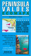
Landkaart en wegenkaart van het Valdes Schiereiland met tekeningen van de voorkomende fauna. Relief, contours, animal colonies, roads, sailing ports,... meer
Landkaart en wegenkaart van het Valdes Schiereiland met tekeningen van de voorkomende fauna.
Relief, contours, animal colonies, roads, sailing ports, glossary in 4 languages. Pictures of sea birds and mammals with scientific and English names. Historical houses.
Vakantiebestemmingen met vergelijkbare kenmerkenMisschien bent u ook geïnteresseerd in andere vakantielanden met de volgende kenmerken: |
Reis en Vakantie Top 10Argentinië is vertegenwoordigd in de volgende reis top10's:
|

- © 2010-2015 top10gezien.nl
- over deze site
- disclaimer
- adverteren
- contact