Highlights van Botswana

Botswana, land van de grote dieren, van de grootste rivier delta ter wereld en van een van de bruutste watervallen ter wereld. Tel daar de Kalahari woestijn bij op, de cultuur van de bosjesmannen en je weet waar jouw volgende vakantie naar toe gaat.
Natuur
- Okavango Delta - de grootste rivierdelta ter wereld
- Kalahari woestijn
- Chobe - verzamelgebied van olifanten


World Heritage Sites
- Tsodilo rotskunst

Typisch
| nationale gerechten | Seswaai |
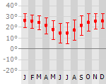
Klimaat
| Temperatuur | Beste tijd voor een reis |
|
|
Typisch
| Officiële landsnaam | Republiek Botswana |
| Hoofdstad | Gaborone |
| Nationaliteit | Botswaan |
| Talen | overig |
| Visum nodig? | Nee |
| Munteenheid | Pula (BWP) |
| Regeringsvorm | parlementaire republiek |
| Grootte t.o.v. Nederland | 14.5 keer groter |
| Bevolking | 1.8 miljoen |
| Bevolkingsdichtheid t.o.v. Nederland | 130.6 keer lager |
| Laagste punt | 513 m |
| Hoogste punt | 1489 m |
Exotische ziekten
- malaria
- hepatitis A
- typhus
Interessante boeken over Botswana
-
Wegenkaart- landkaart Botswana | Tracks4Africa | 19.95 €
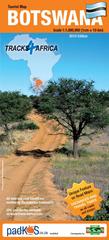
The Tracks4Africa Botswana paper map is designed to be used in conjunction with the T4A GPS Map of Botswana. It is the largest available Botswana ma... meer
The Tracks4Africa Botswana paper map is designed to be used in conjunction with the T4A GPS Map of Botswana. It is the largest available Botswana map at 1:1,000,000 scale, offering you the perfect trip planning tool for your next Botswana holiday.
This T4A paper map series are probably the first comprehensive country maps in the world, offering travel time information for the entire road network, be it on tar, gravel or sand!The roads, tracks, places of interest as well as the distance data and travel time estimates on the map reflect the collective travel experience of the Tracks4Africa community of travellers over the past 10 years, with every single road being GPS recorded and verified by this community.
No need to transfer GPS coordinates from the map to your GPS as everything you see on the map is contained in our T4A GPS Maps. Our maps offer the most comprehensive coverage of tourist destinations in Botswana. Use T4A GPS Maps to navigate you to all the destinations you see on this country map.
Key features:
Large 1:1,000,000 scale
Travel times and distances included on the map
What you see on the paper map is exactly what you get on T4A GPS Maps
Comprehensive set of roads and tracks in nature reserves
Detailed information on camp sites and attractions
Border crossings indicated with opening and closing times
Visit www.tracks4africa.com for detail on places of interest
Complete Kgalagadi Transfrontier Park included
Detailed maps for Moremi, Gaborone, Maun, Kasane and Savuti
Each town is shown with up to date tourist services information
Printed on tear and water resistant PolyArt paper suitable for outdoor use -
Reisgids Lonely Planet Southern Africa - zuidelijk Afrika - Botswana, Lesotho, Malawi, Mozambique, Namibië, Zambia, South Africa, Zimbabwe | Lonely Planet | 26.95 €
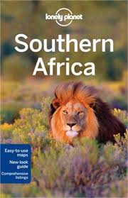
De perfecte reisgids voor zowel de georganiseerde als de zelfstandige reiziger. Naast een algemene inleiding van het land / streek vol met praktisch... meer
De perfecte reisgids voor zowel de georganiseerde als de zelfstandige reiziger. Naast een algemene inleiding van het land / streek vol met praktische informatie over hoe je er het beste kunt reizen: slapen, eten, vervoer, excursies ... alles kun je er in vinden. Engelstalig.
Lonely planet: Our 5th edition of Southern Africa brings you the most extensive coverage of the region. Go on safari in Kruger National Park, taste your way through South Africa's Winelands, glide in a traditional dugout canoe down the Okavango Delta, snorkel in Lake Malawi and be amazed by one of the seven natural wonders of the world, Victoria Falls.
* 146 detailed and easy to use maps
* Special colour chapter on wildlife & habitats
* Detailed itineraries take you from laid-back coasts to unforgettable safaris
* Dedicated music chapter gets you into the African groove
* Green Index highlights the best ecofriendly optionsThis guide covers: Botswana, Lesotho, Malawi, Mozambique, Namibia, South Africa, Swaziland, Zambia, and Zimbabwe.
Vakantiebestemmingen met vergelijkbare kenmerkenMisschien bent u ook geïnteresseerd in andere vakantielanden met de volgende kenmerken: |
Reis en Vakantie Top 10Botswana is vertegenwoordigd in de volgende reis top10's:
|

- © 2010-2015 top10gezien.nl
- over deze site
- disclaimer
- adverteren
- contact