Highlights van Chili
Natuur
- Torres de Paine - trektochten langs gletsjers en eindeloze panorama's
- Lauca - nationaal park in de hoogvlakte van Chili


Overige mooiste bezienswaardigheden, evenementen, activiteiten en attracties
- Grootste zwembad ter wereld (1000 meter) in San Alfonso del Mar
World Heritage Sites
- Nationaal park Rapa Nui
- Kerken van Chiloé
- Historische wijk van de havenstad Valparaíso
- Salpetergroeves Humberstone en Santa Laura
- De mijnstad Sewell

Typisch
| nationale gerechten | empanadas |
| nationale dranken | pisco |
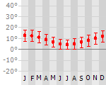
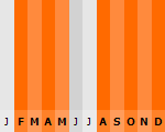
Klimaat
| Kenmerken |
|
| Temperatuur | Beste tijd voor een reis |
|
|
Typisch
| Officiële landsnaam | Republiek Chili |
| Hoofdstad | Santiago |
| Nationaliteit | Chileen |
| Talen | Spaans |
| Visum nodig? | Nee |
| Munteenheid | Chileense Peso (CLP) |
| Regeringsvorm | republiek |
| Grootte t.o.v. Nederland | 18.2 keer groter |
| Bevolking | 16.5 miljoen |
| Bevolkingsdichtheid t.o.v. Nederland | 18.4 keer lager |
| Laagste punt | 0 m |
| Hoogste punt | 6880 m |
Interessante boeken over Chili
-
Wegenkaart - landkaart Chile - Chili | Mapas Naturismo | 11.25 €
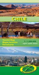
Our new Chile map is ready and it´s fantastic. It´s the best map of Chile available on the market. Highlights are: important and historic sites, mu... meer
Our new Chile map is ready and it´s fantastic. It´s the best map of Chile available on the market.
Highlights are:
important and historic sites, museums and other important places
all the nature reserves
advices for ornithologists and botanicans
exact distance kilometers, fuel stations, hotels, panoramic routes for self drivers
some of most important local folk festivals
-
Reisgids Lonely Planet Chile & Easter Island - Chili en Paaseiland | Lonely Planet | 22.75 €
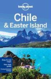
De perfecte reisgids voor zowel de georganiseerde als de zelfstandige reiziger. Naast een algemene inleiding van het land / streek vol met praktisch... meer
De perfecte reisgids voor zowel de georganiseerde als de zelfstandige reiziger. Naast een algemene inleiding van het land / streek vol met praktische informatie over hoe je er het beste kunt reizen: slapen, eten, vervoer, excursies ... alles kun je er in vinden. Engelstalig. Lonely Planet
Climb the rocky spires of Torres del Paine, salsa all night in sizzling Santiago, explore the world's driest desert or follow Che's tracks through the Lakes District. Whether you're looking to brave the wilderness or wind through the wine country, our best-selling, opinion-packed Chile guide will take you to the end of the world...and back.
HEAD SOUTH – expanded coverage of adventura paradise Patagonia with a side trip to Argentina
RAISE A GLASS – Discover Chilean wine with our intoxicating primer by a Colchagua Valley vintner
PLAY HARD – sand board desert dunes, paddle through ice-carved fjords or ski still-smoking volcanoes with our dedicated Outdoors chapter
REST EASY – accomodation for every budget, from rustic mountain refugios and homey hospedajesto luxurious retreats and high-rise hotels
LIVE IT UP – enjoy gourmet meals and top-notch culture in Santiago, uncover Valparaiso's bohemian charms or sunbath on Arica's plentiful beaches

Vakantiebestemmingen met vergelijkbare kenmerkenMisschien bent u ook geïnteresseerd in andere vakantielanden met de volgende kenmerken: |
Reis en Vakantie Top 10Chili is vertegenwoordigd in de volgende reis top10's:
|

- © 2010-2015 top10gezien.nl
- over deze site
- disclaimer
- adverteren
- contact