Highlights van El Salvador
Natuur
- Santa Anavulkaan - een niet meer actieve vulkaan in een mooie omgeving
- Lago de Alegria - een groen zwavelmeer nabij het dorpje Alegria
- Cerro Verde National Park - prachtige natuur nabij Lake Coatepeque


Cultuur
- Tazumal ruïnes - de grootste Maya-site van El Salvador
- Joya de Ceren - het Pompeï van de Amerika's
- San Andres - pre-colombiaanse nederzetting
Sport en avontuur
- La Libertad - een opkomend surfmekka
- rafting
Overige mooiste bezienswaardigheden, evenementen, activiteiten en attracties
- Costa del Sol - strandparadijs in el Salvador
World Heritage Sites
- Archeologische plaats Joya de Cerén

Typisch
| nationale gerechten | Pupusa |
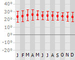
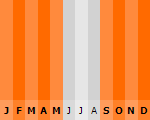
Klimaat
| Kenmerken |
|
| Temperatuur | Beste tijd voor een reis |
|
|
Typisch
| Officiële landsnaam | Republiek El Salvador |
| Hoofdstad | San Salvador |
| Nationaliteit | Salvadoraan |
| Talen | Spaans |
| Visum nodig? | Nee |
| Munteenheid | Amerikaanse Dollar (USD) |
| Regeringsvorm | republiek |
| Grootte t.o.v. Nederland | 2.0 keer kleiner |
| Bevolking | 7.1 miljoen |
| Bevolkingsdichtheid t.o.v. Nederland | 1.2 keer lager |
| Laagste punt | 0 m |
| Hoogste punt | 2730 m |
Exotische ziekten
- hepatitis A
- typhus
- dengue
- leptospirosis
Interessante boeken over El Salvador
-
Reisgids El Salvador | Footprint guides | Richard Arghiris 11.50 €
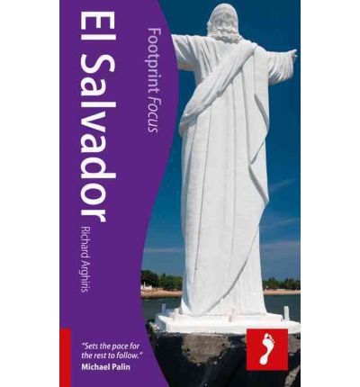
Kleine handzame gids over El Salvador. El Salvador's roads are less travelled compared to other Central American countries, making for a count... meer
Kleine handzame gids over El Salvador.
El Salvador's roads are less travelled compared to other Central American countries, making for a country which retains that elusive quality travellers often look for: adventure. From dramatic volcanic landscapes to blue-green lagoons, from the bustle of San Salvador to the quiet wilderness of El Impossible National Park, this guidebook will help you make the most of your visit to this spectacular country. * Essentials section with indispensable information on getting there and around * Highlights maps of the region so you know what not to miss * Comprehensive, up-to-date listings of where to eat, drink and sleep * Detailed street maps for San Salvador and other key towns * Slim enough to fit in your pocket Loaded with advice and information on how to get around, this concise Footprintfocus guide will help you get the most out of El Salvador without weighing you down. The content of Footprintfocus El Savador guide has been extracted from Footprint's Central America & Mexico Handbook.
-
Wegenkaart - landkaart El Salvador | ITMB | 10.95 €
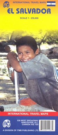
Een degelijke kaart met aanduidingen van o.a. nationale parken, vliegveld, benzinepomp, dirt-roads en kleine plattegrond van hoofdstad. Als overzichts... meer
Een degelijke kaart met aanduidingen van o.a. nationale parken, vliegveld, benzinepomp, dirt-roads en kleine plattegrond van hoofdstad. Als overzichtskaart goed te gebruiken.
Folded paper road and travel map in color. Scale 1:250,000. Distinguishes roads ranging from main highways to other roads. Legend includes trails/tracks, railways, national boundaries, provincial/terrtorial boundaries, National Parks, international airports, domestic aerodromes, points of interest, churches, major archaeological ruins, other archaeological sites, border crossings, beaches, watersports sites. Includes inset map of San Salvador and extensive index.
Vakantiebestemmingen met vergelijkbare kenmerkenMisschien bent u ook geïnteresseerd in andere vakantielanden met de volgende kenmerken: |
Reis en Vakantie Top 10El Salvador is vertegenwoordigd in de volgende reis top10's: |

- © 2010-2015 top10gezien.nl
- over deze site
- disclaimer
- adverteren
- contact