Highlights van Ethiopië
Natuur
- Tanameer - het grootste meer van Ethiopie


World Heritage Sites
- geen

Typisch
| nationale gerechten | doro wat (gestoofde kip) |
Klimaat
| Kenmerken |
|
| Temperatuur | Beste tijd voor een reis |
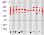
|
|
Typisch
| Officiële landsnaam | Federale Democratische Republiek Ethiopië |
| Hoofdstad | Addis Abeba |
| Nationaliteit | Ethiopier |
| Talen | overig |
| Visum nodig? | Ja |
| Munteenheid | Birr (ETB) |
| Regeringsvorm | federale republiek |
| Grootte t.o.v. Nederland | 27.1 keer groter |
| Bevolking | 78.3 miljoen |
| Bevolkingsdichtheid t.o.v. Nederland | 5.8 keer lager |
| Laagste punt | -125 m |
| Hoogste punt | 4533 m |
Exotische ziekten
- rabies
- malaria
- hepatitis A
- typhus
Interessante boeken over Ethiopië
-
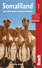
Reisgids Somaliland | Bradt guides | Philip Briggs 22.50 €
Voor vele landen net zo goed, zo niet beter dan de Planet. Beduidend soberder uitgevoerd, maar ook met veel informatie voor backpackers en met veel ... meer
Voor vele landen net zo goed, zo niet beter dan de Planet. Beduidend soberder uitgevoerd, maar ook met veel informatie voor backpackers en met veel kaartmateriaal. Een aanrader!
Little known to the outside world, Somaliland has much to offer the truly intrepid traveller. This pioneering guidebook introduces one of the world’s least chartered travel destinations. Author Philip Briggs covers everything from the low-key capital Hargeisa and mediaeval port of Berbera to peerless rock art sites such as Las Geel, and the scenery and wildlife of the Daallo Escarpment, towering 2,000m high above the pristine reefs of the Gulf of Aden. Somaliland’s ruined cities and historical ports date back 5,000 years and have links with ancient Egypt and Axum in northern Ethiopia, as well as the Ottoman and British Empires. This guide offers background and practical information to every accessible corner of the country with the only real maps in existence of its capital and other large towns, and a section on wildlife.
-
Reisverhaal De drums van de Timkat | Ada Rosman | 18.50 €
.jpg)
Ethiopië: het land van de verbrande gezichten. Een land dat bekend staat als de geboorteplaats van de oudste mens op aarde: Lucy. Een land waar... meer
Ethiopië: het land van de verbrande gezichten. Een land dat bekend staat als de geboorteplaats van de oudste mens op aarde: Lucy. Een land waar meer dan tachtig verschillenden bevolkingsgroepen wonen die allemaal hun eigen cultuur, gewoontes en tradities hebben. Ada Rosman-Kleinjan reisde samen met haar echtgenoot Jan Rosman af naar dit land in oost-Afrika. Reizen door Ethiopië is reizen door verschillende landen. Het Noorden met zijn unieke rotskerken waar priesters nog steeds diensten opdragen en de gelovigen hun geloof belijden. In januari wordt hier het belangrijkste christelijke festival gevierd: het Timkat festival. Met name in Gondar en Lalibela vieren de mensen dagenlang feest en dragen de mooiste kleren. Het Simien National Park waar schuwe luipaarden zich niet laten zien maar waar vriendelijk Gelada apen nieuwsgierig naar de mensen zijn, de apenmannen vol trots hun rode hart tonen en waar bijzondere vogels door de lucht zweven. Axum, dichtbij de grens met Eritrea, waar eindelijk de laatste zuil weer op zijn eigen plekje staat.Het Zuiden waar in de Omo vallei de meest uiteenlopende mensen wonen en de reiziger het gevoel geven terug in de tijd te stappen. De Konso mensen met hun eeuwenoude manier van land bewerken. De vriendelijke Hamer mensen met hun heftige tradities, de Mursi waarbij met name de vrouwen door het dragen van schotellippen opvallen. Bena vrouwen die een kalebas als hoed dragen en waar de mannen zich in strakke rokjes steken en sierlijke speldjes in hun haar dragen.Het Noorden werd op eigen houtje bereisd en door het Zuiden was Abel de chauffeur-gids die Ada Rosman-Kleinjan en Jan Rosman overal brachten waar zij graag naartoe wilden.Ethiopië: een prachtig land met een fascinerende en trotse bevolking.Wat mag je verwachten van dit Wombat reisboek?* 200 pagina’s telt dit reisboek/reisverslag* 14 pagina’s met schitterende kleurenfoto’s zijn te bewonderen in dit reisboek/reisverslag* een uitgebreide literatuurlijst tref je aan in dit reisboek/reisverslag* een verklarende woordenlijst maken dit reisboek/reisverslag compleet
Vakantiebestemmingen met vergelijkbare kenmerkenMisschien bent u ook geïnteresseerd in andere vakantielanden met de volgende kenmerken: |
Reis en Vakantie Top 10Ethiopië is vertegenwoordigd in de volgende reis top10's:
|

- © 2010-2015 top10gezien.nl
- over deze site
- disclaimer
- adverteren
- contact