Highlights van Griekenland
Natuur
- Tempel van Apollo Epicurius te Bassae
- Archeologische plaats Delphi
- Akropolis van Athene
- De berg Athos
- Meteoraklooster
- Oudchristelijke en Byzantijnse monumenten van Thessaloniki
- Archeologische plaats Epidaurus
- De middeleeuwse stad Rhodos
- Mystras
- Archeologische plaats Olympia
- Delos
- Kloosters van Daphni & Osios Loukas en Nea Moni van Chios
- Pythagoreion en Heraion van Samos
- Archeologische plaats Vergina
- Archeologische plaatsen Mycene en Tiryns
- Historisch centrum Chorá met het Klooster van de Heilige Johannes "de Theoloog" en de Grot van de Apocalypsis op het eiland Pátmos
- De oude stad van Korfoe


Cultuur
- Parthenon - het beroemdste monument op de Acropolis en van het oude Griekenland

Typisch
| nationale gerechten | moussaka |
| nationale dranken | Ouzo |
| beroemd om | homerus ilias en oddysee peleponnesus |
Klimaat
| Kenmerken |
|
| Temperatuur | Beste tijd voor een reis |
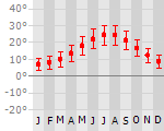
|
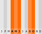
|
Typisch
| Officiële landsnaam | Helleense Republiek |
| Hoofdstad | Athene |
| Nationaliteit | Griek |
| Talen | overig |
| Visum nodig? | Nee |
| Munteenheid | Euro (EUR) |
| Regeringsvorm | parlementaire republiek |
| Grootte t.o.v. Nederland | 3.2 keer groter |
| Bevolking | 10.7 miljoen |
| Bevolkingsdichtheid t.o.v. Nederland | 4.9 keer lager |
| Laagste punt | 0 m |
| Hoogste punt | 2917 m |
Low-cost airlines
- Arke Fly
- Air Berlin
- Transavia
- Corendon
- Thomas Cook
Interessante boeken over Griekenland
-
Road Editions 302 Paxos - Antipaxos wegenkaart - landkaart Paxos - Antipaxos | 8.25 €
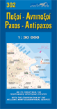
Gedetailleerde wegenkaart met aanduiding van de wandelwegen, lijst van hotels en toeristische informatie. Voor alle doeleinden een zeer geschikte ka... meer
Gedetailleerde wegenkaart met aanduiding van de wandelwegen, lijst van hotels en toeristische informatie. Voor alle doeleinden een zeer geschikte kaart. These two Ionian islands are not as small as you think. They have many roads, beaches, settlements, and places to discover. That is why you need this well-designed ROAD map on which all the information a traveller may require is marked clearly and precisely.
As all ROAD maps, it was designed following careful and exhaustive onsite research. We used the most advanced technology to precisely map out the entire road networks of these two islands, we measured the distances in kilometers from intersection to intersection with precision instruments, marked all country churches, monasteries as, of course, the beaches and the roads leading to them, the altitudes of mountain peaks, the footpaths we were able to locate and record, the location names as they are currently in use, the lighthouses and much more.
The most characteristic information regarding the history, major sights, beaches and modern day Paxi and Antipaxi are provided in brief texts, in Greek and English, on the front of the map.
The contour lines on this map (at 100m intervals), the coastline and hydrography were provided by Hellenic the Military Geographic Service.
-
Wegenkaart wandelkaart 449 Central Crete - Kreta centraal | Terrain Maps | 11.50 €

Gedetailleerde wegenkaart en wandelkaart met alle kleine wegen, wandelpaden, hoogtelijnen en toeristische informatie aangegeven. Alle tekst is tweet... meer
Gedetailleerde wegenkaart en wandelkaart met alle kleine wegen, wandelpaden, hoogtelijnen en toeristische informatie aangegeven. Alle tekst is tweetalig in Engels en Grieks en de waterproof kaart is geschikt voor gebruik met GPS.
Terrain’s map of Central Crete provides travelers with everything they need:- Scale of 100.000, which attributes all the information with clarity and in detail.
- Map data processed within a GIS environment, resulting in great accuracy.
- Double coordinate system, WGS 84 and ΕΓΣΑ 87, completely compatible with GPS.
- It is printed on Polyart material, making it totally waterproof and rip-proof. You can fold it and unfold it a hundred times, fold it in irregular ways, dunk it in the sea or leave it out in the rain. This map is indestructible!
- Clear symbols, easily readable fonts, rich colors and excellent arrangement of every element make the map extremely friendly to the user.
- Unique wealth of information. Every village, every road (including their distance in km), every sight, every beach, every gas station, the camping areas and much more, are all included in the map.
- The most important trails of the area are marked in the map, with clear lines, in two categories (main and secondary trails), including their exact distance in km, as well as the mountain refuges.
- For the first time in a map of Crete, the bolted canyoning routes and the climbing crags of the area are included. Moreover, suggested scenic routes are marked with a green shadow on the map. Also, a full index of the place names and the archaeological sites is included, as well as a detailed townplan of Heraklion in the scale of 1:4.500.

Vakantiebestemmingen met vergelijkbare kenmerkenMisschien bent u ook geïnteresseerd in andere vakantielanden met de volgende kenmerken: |
Reis en Vakantie Top 10Griekenland is vertegenwoordigd in de volgende reis top10's:
|

- © 2010-2015 top10gezien.nl
- over deze site
- disclaimer
- adverteren
- contact