Highlights van Europa
Typisch
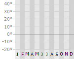
Klimaat
| Temperatuur | Beste tijd voor een reis |
|
|
Typisch
| Officiële landsnaam | Europa |
Interessante boeken over Europa
-
Stadsplattegrond - plattegrond Aberdeen | Collins | 9.25 €
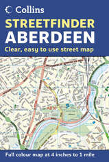
Duidelijke stadsplattegrond van Aberdeen met register. This map covers at a scale of 4 inches to 1 mile with central Aberdeen at 6.5 inches to 1 mile... meer
Duidelijke stadsplattegrond van Aberdeen met register.
This map covers at a scale of 4 inches to 1 mile with central Aberdeen at 6.5 inches to 1 mile. It is a detailed street map displaying a wealth of information without sacrificing clarity. It covers an extensive area of Aberdeen and the surrounding villages as a fold out map. The map is packed with information including street and place names plus road classifications, car parks, schools, hospitals, post offices, police stations and a whole host of other detail. It includes: central area of city shown at extra large scale to aid clarity; land use fully colour coded; full index to street names; and postcode districts. The area of coverage extends from Dyce and the airport in the north to Charlestown in the south, and from Milltimber in the west to the coast in the east. It also includes insets of Peterculter, Westhill, Portlethen and Newtonhill. This is a general purpose map; ideal for residents, businesses and visitors.
-
Wandelkaart 1128 Langenthal | topografische kaart Bundesamt 25.000 | 13.75 €
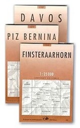
Zeer gedetailleerde wandelkaart van een deel van Zwitserland. De topografische details van deze kaarten zijn onovertroffen; de werkelijkhei... meer
Zeer gedetailleerde wandelkaart van een deel van Zwitserland. De topografische details van deze kaarten zijn onovertroffen; de werkelijkheid is perfect weergegeven op deze kaart van uitzonderlijk hoog niveau. Ze zijn geschikt voor alle soorten gebruik: voor eenvoudige wandeltochten in simpel terrein tot zware bergtochten en beklimmingen van de grote toppen in de Alpen. Bedenk wel dat de kaart in uiterlijk beperkt blijft tot de topografische details: er is geen toeristische informatie ingetekend als camping of gemarkeerde paden. Wandelpaden staan er wel op in gestippelde zwarte lijnen, maar zijn ondergeschikt aan de topografie. Als kaart is het de meest gedetailleerde die er te vinden is en - zoals gezegd - van topkwaliteit. De kaarten worden gemiddeld om de 3 tot 4 jaar vernieuwd, maar er zijn ook oudere kaarten die gewoon nog de laatste editie zijn.
Voor de 'gewone' bergwandelaar zijn de Kompass-wandelkaarten die inmiddels bijna heel Zwitserland dekken wellicht nuttiger: schaal 1:50.000 met ingetekende wandelroutes en andere informatie.
Vakantiebestemmingen met vergelijkbare kenmerkenMisschien bent u ook geïnteresseerd in andere vakantielanden met de volgende kenmerken: |
Reis en Vakantie Top 10Europa is vertegenwoordigd in de volgende reis top10's: |
Bestemmingen in Europa

- © 2010-2015 top10gezien.nl
- over deze site
- disclaimer
- adverteren
- contact