Highlights van Groenland


Typisch
| nationale gerechten | suaassat - gekookte zeehondenvlees met rijst en uien |
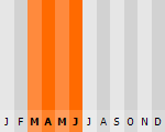
Klimaat
| Kenmerken |
|
| Temperatuur | Beste tijd voor een reis |
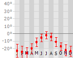
|
|
Typisch
| Officiële landsnaam | Kalaallit Nunaa |
| Hoofdstad | Nuuk |
| Nationaliteit | Groenlander |
| Talen | overig, engels |
| Visum nodig? | Nee |
| Munteenheid | Deense Kroon (DKK) |
| Regeringsvorm | parlementaire democratie |
| Grootte t.o.v. Nederland | 52.2 keer groter |
| Bevolking | 0.1 miljoen |
| Bevolkingsdichtheid t.o.v. Nederland | 15083.3 keer lager |
| Laagste punt | 0 m |
| Hoogste punt | 3700 m |
Interessante boeken over Groenland
-
Landkaart - wegenkaart Groenland - Grönland | Reise Know How | 10.50 €
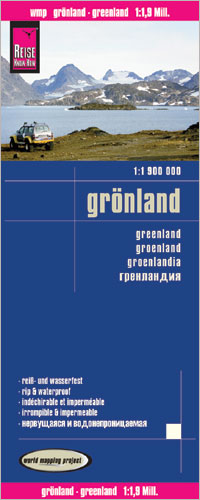
Tweetalige kaart (Engels en Duits). Door ingetekende lengte- en breedtegraden is het gebruik van GPS mogelijk. Met hoogtelijnen. Gedrukt op water- e... meer
Tweetalige kaart (Engels en Duits). Door ingetekende lengte- en breedtegraden is het gebruik van GPS mogelijk. Met hoogtelijnen. Gedrukt op water- en scheurvast papier!Diese Landkarte erscheint in der Landkartenserie world mapping project™ bei Reise Know-How. Kennzeichnend ist die hochwertige, klare und moderne kartografische Darstellung.– Höhenlinien mit Höhenangaben– Farbige Höhenschichten– Klassifiziertes Straßennetz mit Entfernungsangaben– Sehenswürdigkeiten– Ausführlicher Ortsindex– GPS-Tauglichkeit durch Längen- und Breitengrade– Fünfsprachige Legende (deutsch, englisch, französisch, spanisch, russisch) -
Reisgids Groenland - ReiseTascheBuch Grönland Mit 10 Entdeckungstouren | Dumont | 17.75 €
.jpg)
Duitstalig reisboek met beschrijvingen van bezienswaardigheden, praktische informatie en veel aandacht voor de geschiedenis, cultuur en natuur. DuMo... meer
Duitstalig reisboek met beschrijvingen van bezienswaardigheden, praktische informatie en veel aandacht voor de geschiedenis, cultuur en natuur.
DuMont Reise-Taschenbuch Grönland von Sabine Barth
Mit Extra-Reisekarte und 10 Entdeckungstouren, Rundgänge und Ausflüge, Tipps für Genießer und Aktive, persönlich bewertete Adressen - und ein aktuelles Porträt des Landes
Diese riesige arktische Insel, zu 85% von Eis bedeckt, ist ein ganz besonderes Kleinod auf unserem Planeten - und ein Reisetraum. Fünf vollkommen unterschiedliche Inselgebiete plus die kleine Hauptstadt Nuuk stellt die Autorin in diesem Band vor. Im Süden besucht der Reisende malerisch gelegene Orte, stößt auf Ruinen der Wikinger, die hier ihr Glück suchten, und wandert über grüne Wiesen. Im Westen liegen die größten Orte mit einer guten Infrastruktur für Fjordfahrten oderBergtouren. Die Diskobucht mit ihren gigantischen Eisbergen ist eines der Highlights Grönlands. Im Norden und Osten kann man noch das ursprüngliche Leben der Jäger kennenlernen, hier erstreckt sich das Inlandeis an vielen Stellen direkt bis ins Meer.Die Autorin ist eine intime Kennerin Grönlands und eine erfahrene Reiseleiterin, die seit Jahren alle Veränderungen im Land beobachtet. Auf ihre zahlreichen Tipps für Ausflüge und Wanderungen ist ebenso Verlass wie auf die umfangreichen Informationen über Land und Leute. Exkurse und Reportagen vermitteln Einblicke in die Besonderheiten der Kultur, der Lebensweise und Geschichte der Grönländer sowie der Inuit im Speziellen. Für den Individualreisenden gibt es alle wichtigen Infos zu Transport, Unterkunft, Verpflegung und Aktivitäten wie Hundeschlittenfahrten, Walbeobachtungen oder Kajaktouren. Die zahlreichen, kleinen Übersichtskarten in dem handlichen Band helfen bei der Orientierung in den einzelnen Regionen.
Vakantiebestemmingen met vergelijkbare kenmerkenMisschien bent u ook geïnteresseerd in andere vakantielanden met de volgende kenmerken: |
Reis en Vakantie Top 10Groenland is vertegenwoordigd in de volgende reis top10's:
|

- © 2010-2015 top10gezien.nl
- over deze site
- disclaimer
- adverteren
- contact