Highlights van Ierland
Natuur
- Strangord Lough - broedgebied voor een grote diversiteit aan vogels


World Heritage Sites
- Archeologisch complex de Bend of the Boyne
- Skellig Michael

Typisch
| nationale gerechten | Irish Stew |
| nationale dranken | Ierse Wiskey |
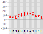
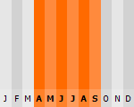
Klimaat
| Kenmerken |
|
| Temperatuur | Beste tijd voor een reis |
|
|
Typisch
| Officiële landsnaam | Ierland |
| Hoofdstad | Dublin |
| Nationaliteit | Ier |
| Talen | overig, engels |
| Visum nodig? | Nee |
| Munteenheid | Euro (EUR) |
| Regeringsvorm | republiek, |
| Grootte t.o.v. Nederland | 1.7 keer groter |
| Bevolking | 4.2 miljoen |
| Bevolkingsdichtheid t.o.v. Nederland | 6.8 keer lager |
| Laagste punt | 0 m |
| Hoogste punt | 1041 m |
Low-cost airlines
- Ryanair
- BMI
- Aerlingus
Interessante boeken over Ierland
-
Reisgids Lonely Planet Dublin City Guide | Lonely Planet | 18.95 €
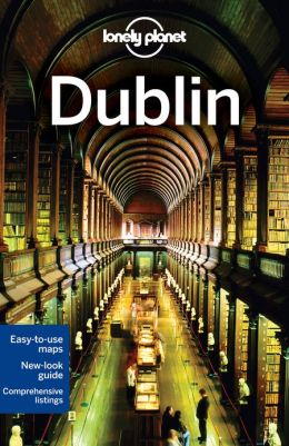
De perfecte reisgids voor zowel de georganiseerde als de zelfstandige reiziger. Naast een algemene inleiding van de stad vol met praktische informat... meer
De perfecte reisgids voor zowel de georganiseerde als de zelfstandige reiziger. Naast een algemene inleiding van de stad vol met praktische informatie over hoe je er het beste kunt reizen: slapen, eten, vervoer, excursies ... alles kun je er in vinden.
Dublin’s key ingredients: a thousand-year history, marinated until rich in heritage and sprinkled with hedonism. Visit and enjoy.Inspirational images, 3D illustrations, city walks and recommendations from our expert authorsPlanning features and top itineraries to help you plan the perfect tripLocal secrets and hidden travel gems that will make your trip uniquePLUS top sights in 3D, best city walks, Dublin’s nightlife uncovered and day trips to historic sitesCoverage includes: Plan Your Trip, Grafton Street & Around, Merrion Square & Around, Temple Bar, Kilmainham & the Liberties, North of the Liffey, Docklands & the Grand Canal, Day Trips, Understand Dublin and Survival Guide. -
Wandelkaart Ierland 33 Leitrim, Longford, Roscommon, Sligo discovery | Ordnance Survey | 12.50 €
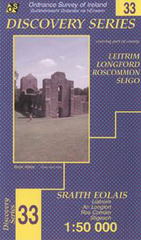
Zeer gedetailleerde topografische kaart met een aantal toegevoegde toeristische symbolen voor bijv. Bezienswaardigheden en campings. Met hoogtelijne... meer
Zeer gedetailleerde topografische kaart met een aantal toegevoegde toeristische symbolen voor bijv. Bezienswaardigheden en campings. Met hoogtelijnen, mooi kleurgebruik en ingetekende lange-afstands-wandelroutes.
Vakantiebestemmingen met vergelijkbare kenmerkenMisschien bent u ook geïnteresseerd in andere vakantielanden met de volgende kenmerken: |
Reis en Vakantie Top 10Ierland is vertegenwoordigd in de volgende reis top10's:
|

- © 2010-2015 top10gezien.nl
- over deze site
- disclaimer
- adverteren
- contact