Highlights van Italië

Italië staat bekend om zijn azuurblauwe zeeën, smaakvolle pasta gerechten zoals pizza en lasagna en natuurlijk de ruige natuur van de Dolemiten. Italië is ook het land met het grootste aantal wereld erfgoederen. Dat zie je direct als je door het centrum van Rome loopt, wat in feite een grote openluchtmuseum is en een feest voor cultuurliefhebbers. Ook de vakantiegangers die zon, zee en strand zoeken op een van de vele eilandjes of meren van Italië, zouden minstens een dag door Rome moeten wandelen
Natuur
- Cinque Terre - Grillige rotsen en slingerende weggetjes liggen hier aan de azuur blauwe wateren van de Middellandse Zee
- Abruzzo National Park - in het park ligt een prachtig meer waar het 's zomers goed toeven is
- Italiaanse meren dictrict - Lago Maggiore, Lago di Lugano en Lago di Como
- Nationaal Park Gran Paradiso - het oudste nationale park van Italië, gelegen in het Aosta dal
- Blauwe Grot - een van de mooiste zeegrotten ter wereld
- Aardpijlers van Ritten - merkwaardig gevormde rotsen in Zuid-Tirol
- Etna vulkaan - de hoogste actieve vulkaan van Europa
- Alcantarakloof - een prachtige, smalle diepe kloof op het eiland Sicilië


Cultuur
- Pantheon - indrukwekkende tempel in het hart van Rome
- San Marco - rijk versierde basiliek uit 800 na Chr.
- Scheve toren van Pisa - al tijdens de bouw begon deze beroemde toren te verzakken
- Duomo - deze gotische kerk met overvloedige versiering is een Italiaans meesterwerk
- Santa Maria del Fiore - een fantastische koepel en klokkentoren uit de 14e eeuw
- Parco della Musica - enorm muziekcomplex in de vorm van drie muziekinstrumenten
- Colosseum - gigantisch amfitheater waar in de oudheid gladiatorengevechten werden gehouden
- Venetië - middeleeuwse stad gebouwd op honderden eilanden
- Pompeii - ervaar de historie van deze onder lava bedolven stad
- Florence - hoofdstad van de regio Toscane en vakantiestad van bruggen, paleizen, pleinen en kerken
Sport en avontuur
- Matterhorn - bergbeklimmekka, gedeeld met Zwitserland
- Dolomieten - de Via Ferrata (Klettersteigen) heeft zijn oorsprong in dit gebergte
- Mountainbiken in de Alpen, Sardinië of Sicilië
Mooiste routes
- Costiera Amalfitana - prachtige kustweg langs de middellandse zee
Overige mooiste bezienswaardigheden, evenementen, activiteiten en attracties
- De watervallen van Saturnia - neem een duik in deze geneeskrachtige zwavelhoudende watervallen in de buurt van Toscane
- Internationale Rome Film Festival
- Stromboli - een actieve vulkaan waar je lavastralen kunt zien spuiten
World Heritage Sites
- De vroegchristelijke monumenten van Ravenna
- De historische binnenstad van Pienza
- Het 18e-eeuwse Paleis van Caserta met park en aquaduct van Vanvitelli en het San Leuciocomplex
- Residenties van het koninklijk huis van Savoye
- Orto botanico di Padova - de botanische tuin in Padua
- Portovenere
- Cinque Terre en de eilanden Palmaria & Tino en Tinetto
- De kathedraal van Modena & Torre Civica en Piazza Grande te Modena
- Archeologische opgravingen bij Pompeii & Herculaneum en Torre Annunziata
- Costiera Amalfitana
- Archeologische opgravingen van Agrigento
- Villa Romana del Casale
- Su Nuraxi di Barumini
- Nationale parken Cilento en Vallo di Diano met de archeologische terreinen van Paestum en Velia en de Certosa di Padula
- De historische binnenstad van Urbino
- Archeologische opgravingen en de Basiliek van de Patriarch in Aquileia
- Villa Adriana (Tivoli)
- De Eolische Eilanden
- Assisi - de Basiliek van San Francesco en andere terreinen van franciscanen
- De binnenstad van Verona
- Villa d'Este - Tivoli De laatbarokke steden in het Val di Noto
- Heilige bergen van Piëmont en Lombardije
- Etruskische necropolissen te Cerveteri en Tarquinia
- Het landschap van de Val d'Orcia
- Syracuse en de Rotsnecropolis van Pantalica
- Le Strade Nuove en de Palazzi dei Rolli in Genua
- Rotstekeningen in Valcamonica & Kerk en dominicanerklooster Santa Maria delle Grazie (Milaan) met "Het laatste avondmaal" van Leonardo da Vinci
- Historisch centrum van Rome & de bezittingen van de Heilige Stoel in die stad die speciale territoriale rechten heeft en San Paolo Fuori le Mura
- De historische binnenstad van Florence
- Venetië met zijn lagune
- Het Domplein (Campo dei Miracoli) van Pisa
- De historische binnenstad van San Gimignano
- I Sassi di Matera
- De stad Vicenza en de Palladische Villa's van Veneto
- De historische binnenstad van Siena
- De historische binnenstad van Napels
- Crespi d'Adda
- Ferrara in de Podelta
- Castel del Monte
- De trulli van Alberobello (Apulië)

Typisch
| nationale gerechten | pizza |
| nationale dranken | espresso |
| beroemd om | pizza en pasta fiat dolomieten/ trentino italiaanse riveria lombardije/ merengebied peimonte aosta-dal povlakte sardinie sicilie toscane umbrie Vespa Michelangelo Prada Gucci Dolce & Gabbana mafia |
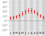
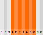
Klimaat
| Kenmerken |
|
| Temperatuur | Beste tijd voor een reis |
|
|
Typisch
| Officiële landsnaam | Italiaanse Republiek |
| Hoofdstad | Rome |
| Nationaliteit | Italiaan |
| Talen | overig |
| Visum nodig? | Nee |
| Munteenheid | Euro (EUR) |
| Regeringsvorm | republiek |
| Grootte t.o.v. Nederland | 7.3 keer groter |
| Bevolking | 58.1 miljoen |
| Bevolkingsdichtheid t.o.v. Nederland | 2.1 keer lager |
| Laagste punt | 0 m |
| Hoogste punt | 4748 m |
Tags
Bergen Zee en strand mediterraan landklimaat bergklimaat Wintersport Duiken Kamperen middellandse zee Euro landLow-cost airlines
- Ryanair
- Easy Jet
- Air Berlin
- BMI
- Transavia
- Thomas Cook
- Germania Express
- Meridiana
Interessante boeken over Italië
-
Wegenkaart - landkaart Sardegna, Sardinië, Sardinie - fietskaart | Touring club Italiano TCI 1:200.000 | 9.95 €
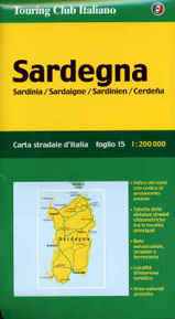
Alle bladen zijn nog niet zo lang geleden vernieuwd en zijn nu gedrukt op een water-en scheurvast materiaal. De weergave van het reliëf is erg ... meer
Alle bladen zijn nog niet zo lang geleden vernieuwd en zijn nu gedrukt op een water-en scheurvast materiaal. De weergave van het reliëf is erg mooi op deze wegenkaarten. Daarom zijn ze niet alleen geschikt als gedetailleerde autokaart, maar ook als fietskaart. Italie valt in 15 bladen. Touring Club Italiano landkaarten /TCI autokaarten Italië.
Ook onder de fietsers - bij gebrek aan echte fietskaarten - staat deze kaartenserie goed aangeschreven: als fietskaart dus prima te gebruiken.
De uitgebreide wegenkaarten van Touring Club Italiano zijn zeker een must voor de vakantieganger die Italië met de auto wil verkennen. De Touring Club kaarten zijn voor bijna elke regio verkrijgbaar. Verder wordt er aangegeven waar de mooie plekjes te vinden zijn. De groen onderstreepte plaatsen zijn interessant, plaatsen in een groen kader zijn erg interessant en wanneer er een groen vak om een plaatsnaam is gedrukt, is de plek bijzonder leuk om te bezoeken. Ook zijn de mooiste routes in groen gedrukt. De legenda is 1:200 000, waarmee deze kaarten vergeleken met de ANWB gedetailleerder zijn.
-
Wandelkaart 041 Obervinschgau - Alta Val Venosta | Kompass | 11.95 €

Goede wandelkaart met vrijwel alle topografische details en ingetekende routes. Ook met symbolen voor toeristische bezienswaardigheden, register. Be... meer
Goede wandelkaart met vrijwel alle topografische details en ingetekende routes. Ook met symbolen voor toeristische bezienswaardigheden, register. Berghutten duidelijk weergegeven. Gevaarlijke wandelroutes zijn goed herkenbaar. GPS toepasbaar. Inclusief een Duitstalig boekje met informatie en routesuggesties.
KOMPASS-Wanderkarten enthalten alles Wissenswerte für Wanderer wie aktuelle Wanderwege mit Markierungen, empfehlenswerte Radrouten und wichtige touristische Informationen.
Der topographische Inhalt wird bei aller Detailgenauigkeit leicht lesbar und anschaulich dargestellt.
Die Rückseite (deutsch und italienisch) informiert über Orte und Schutzhütten sowie empfehlenswerte Touren, Sehenswürdigkeiten und Freizeiteinrichtungen.
Vakantiebestemmingen met vergelijkbare kenmerkenMisschien bent u ook geïnteresseerd in andere vakantielanden met de volgende kenmerken: |
Reis en Vakantie Top 10Italië is vertegenwoordigd in de volgende reis top10's:
|

- © 2010-2015 top10gezien.nl
- over deze site
- disclaimer
- adverteren
- contact