Highlights van Kenia
Natuur
- Masai Mara - prachtig landschap zoals je dat ziet in natuurfilms. En toeristisch
- Tsavo - nationaal park half zo groot als Nederland


World Heritage Sites
- Nationaal park Mount Kenya
- Nationaal park van het Turkanameer
- De oude stad Lamu

Typisch
| nationale gerechten | Ugali |
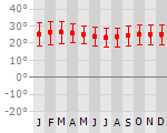
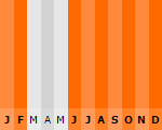
Klimaat
| Kenmerken |
|
| Temperatuur | Beste tijd voor een reis |
|
|
Typisch
| Officiële landsnaam | Republiek Kenia |
| Hoofdstad | Nairobi |
| Nationaliteit | Keniaan |
| Talen | overig, engels |
| Visum nodig? | Ja |
| Munteenheid | Keniaanse Shilling (KES) |
| Regeringsvorm | republiek |
| Grootte t.o.v. Nederland | 14.0 keer groter |
| Bevolking | 38.0 miljoen |
| Bevolkingsdichtheid t.o.v. Nederland | 6.2 keer lager |
| Laagste punt | 0 m |
| Hoogste punt | 5199 m |
Low-cost airlines
- Arke Fly
- Air Berlin
- Martinair
- Thomas Cook
Exotische ziekten
- malaria
- hepatitis A
- typhus
Interessante boeken over Kenia
-
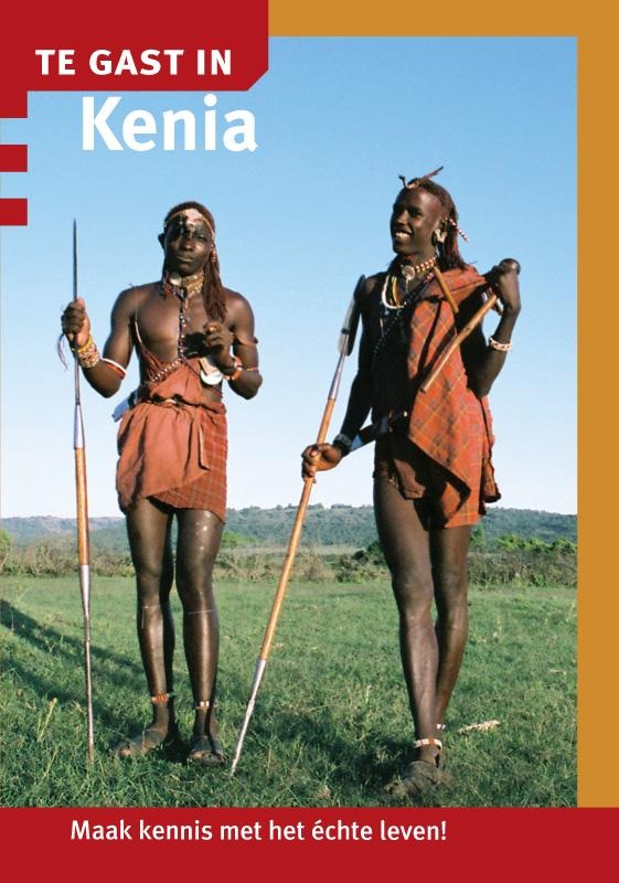
Reisgids - Te gast in Kenia | Informatie Verre Reizen | 8.95 €
Samengesteld door en voor reizigers: verhalen van mensen die er gewoond of gereisd hebben. Literatuurlijst, praktische tips, vooral veel achtergrond- ... meer
Samengesteld door en voor reizigers: verhalen van mensen die er gewoond of gereisd hebben. Literatuurlijst, praktische tips, vooral veel achtergrond- en cultuur informatie.
In de geheel vernieuwde landenreeks TE GAST IN - nu als pocketuitgave en geheel in kleur - is onlangs een uitgave verschenen over Kenia. Het boekje geeft een goed inzicht in de levenswijze en omgangsvormen van de Keniaanse bevolking.
Een bezoek aan dit Oost Afrikaanse land staat garant voor bijzondere ontmoetingen. Niet alleen met de duizenden zebra's en gnoes in het Masai Marawildpark, maar ook met de gastvrije bevolking. Tijdens een taxirit door Nairobi vertelt Kangethe je in geuren en kleuren vertelt over zijn taxibusiness. Op ontdekkingstocht op de hellingen van Mount Kenya nemen keuterboeren je graag op sleeptouw door de frisgroene thee en koffievelden. Halverwege onthalen ze je op een bakje home made coffee. Met of zonder geroosterde termieten als snack. In het droge noorden van Kenia maak je kennis met de rituelen van de kleurrijke Samburu, een herdersvolk dat nauw verwant is aan de Maasai. En aan de kust bij Lamu valt je een hartelijk welkom ten deel tijdens het jaarlijkse Maulidi festival, een spektakel waar pelgrims van heinde en verre op af komen.
Het boekje bevat daarnaast praktische reistips en een woordenlijst Oshivambo en Afrikaans. -
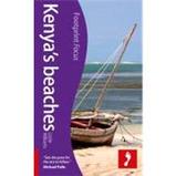
Reisgids Kenya´s Beaches | Footprint | 12.75 €
Handige en handzame reisgids van de kustlijn en stranden van Kenya. Footprintfocus Kenya’s beaches is packed with information on some of Africa’s mos... meer
Handige en handzame reisgids van de kustlijn en stranden van Kenya.
Footprintfocus Kenya’s beaches is packed with information on some of Africa’s most beautiful beaches. From top-class beachside hotels to dense coastal forests, this guide will prove an invaluable companion.
Lie back and relax on some of Africa's most beautiful white sand beaches. When you get fed up of chilling out in the sun try something more adventurous; from diving to windsurfing, there’s a host of activities on offer. Kenya’s coastline has more than just beachside hotels however, as the homeland of Swahili culture this is a region with a unique identity. From the bustle of Mombasa to the wonder of Wasini Island, this Footprintfocus guide will prove an invaluable companion.
· Essentials section with tips on getting there and around.
· Background section with fascinating information on the region’s unique history and culture.
· Comprehensive listings of where to eat & sleep, including detailed information on beach resorts.
· Detailed street maps for Mombasa and other important towns.
· Slim enough to fit in your pocket.
Loaded with advice and information, this concise Footprintfocus guide will help you get the most out of Kenya’s beaches without weighing you down.
Reis en Vakantie Top 10Kenia is vertegenwoordigd in de volgende reis top10's:
|

- © 2010-2015 top10gezien.nl
- over deze site
- disclaimer
- adverteren
- contact