Highlights van Marokko
World Heritage Sites
- Medina van Fez
- Medina van Marrakesh
- Ksar van AitBenHaddou
- Medina van Meknes
- De Romeinse opgravingen van Volubilis
- Medina van Tétouan
- Medina van Essaouira
- De Portugese stad Mazagan

Typisch
| nationale gerechten | couscous, kleinkorrelige 'rijst' van durumtarwe |
| beroemd om | rif gebergte atlas gebergte |
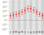
Klimaat
| Kenmerken |
|
| Temperatuur | Beste tijd voor een reis |
|
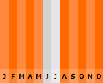
|
Typisch
| Officiële landsnaam | Koninkrijk Marokko |
| Hoofdstad | Rabat |
| Nationaliteit | Marokkaan |
| Talen | arabisch, frans |
| Visum nodig? | Nee |
| Munteenheid | Dirham (MAD) |
| Regeringsvorm | constitutionele monarchie |
| Grootte t.o.v. Nederland | 10.8 keer groter |
| Bevolking | 34.3 miljoen |
| Bevolkingsdichtheid t.o.v. Nederland | 5.2 keer lager |
| Laagste punt | -55 m |
| Hoogste punt | 4165 m |
Tags
Bergen Zee en strand mediterraan woestijn steppe bergklimaat Wintersport Duiken Backpacken sahara rotsklimmenLow-cost airlines
- Ryanair
- Air Berlin
- Transavia
- Thomas Cook
Interessante boeken over Marokko
-
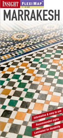
Stadsplattegrond - Landkaart Marrakech | Insight FlexiMap | 10.25 €
Geplastificeerde stadsplattegrond van Marrakech van het centrum met een deel er omheen. Fleximap: Marrakesh" includes 5 maps. The main map (1... meer
Geplastificeerde stadsplattegrond van Marrakech van het centrum met een deel er omheen.
Fleximap: Marrakesh" includes 5 maps. The main map (1:15 000) shows entire city, with points of interest and general tourist information clearly marked. There is also a detailed map of the city centre (1:7,000) to help you find your way around the maze of narrow streets. A useful route planning map of the region around Marrakesh (1:900,000) helps you to plan trips to the nearby Atlas Mountains as well as into the desert and to the coast. Also included is a map of central Agadir (1:15,000), and an overview map (1:45,000,000) of the northern half of Africa. As well as making the map easy to fold and extra-durable, the laminated finish allows you to mark your itinerary on the map and then wipe it off afterwards. To help you plan your trip and prioritise the must-see sights, "Marrakesh" also includes a list - with descriptions and photographs - of 29 recommended sights in the city and further afield, divided by theme and linked to the mapping by numbered markers. There is also a handy information section with concise details on getting around the region, tourist offices, money, tipping, opening times, public holidays, telecommunications, emergency telephone numbers, and climate.
-
Campinggids Gandini Campings du Maroc, Mauretanië (Marokko) 2013-2014 | Guide J. Gandini - Serre Editeur | 23.95 €
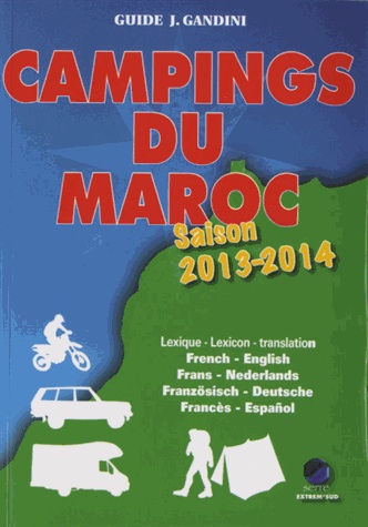
Campinggids van Marokko, met goede beschrijvingen van de campings, routebeschrijving en voorzieningen. Geen foto's, toch onmisbaar voor de... meer
Campinggids van Marokko, met goede beschrijvingen van de campings, routebeschrijving en voorzieningen. Geen foto's, toch onmisbaar voor de kampeerder en doorgaande Sahara - Afrika rijder. Let op: Franstalig! Maar met klein Frans-Nederlands woordenboekje.
NOUVELLE ÉDITION 2013-2014Entièrement refondue, tout en couleurs, illustré.Depuis quelques années, le Maroc voit affluer quantité de camping-cars européens, en majorité occupés par des jeunes et moins jeunes qui viennent passer quelques semaines ou quelques mois au soleil. D'autre part, avec la location de véhicules tout-terrain sans chauffeur, de nombreux amateurs de pistes sillonnent le pays. Jusqu'à ce jour, aucun guide n'indiquanit sérieusement les possibilités qui leur étaient offertes pour faire escale et les services mis à leur disposition. Jacques Gandini et Emile Verhooste ont visité et analysé plus de 200 campings ou assimilés, dont les 2/3 sont dignes de recevoir le public grâce à ce guide critique.Plus de 200 campings ou aires d'accueil visités, analysés et classés par catégorie. Avec tarifs, services proposés et points GPS.AVEC LEXIQUE BILINGUE : ENGLISH, NEDERLANDS, DEUTSCH, ESPAÑOL


Vakantiebestemmingen met vergelijkbare kenmerkenMisschien bent u ook geïnteresseerd in andere vakantielanden met de volgende kenmerken: |
Reis en Vakantie Top 10Marokko is vertegenwoordigd in de volgende reis top10's: |

- © 2010-2015 top10gezien.nl
- over deze site
- disclaimer
- adverteren
- contact