Highlights van Mexico
Natuur
- Las Grutas de Garcia - grottenstelsel in het Sierra del Frailegebergte
- Cenoti Zaci - ondergrondse rivieren in Yucatan
- La Bufadora - geiser van 24 meter hoogte bij Punta Banda
- Vlinderbomen in het El Rosarioreservaat
- Barranca del Cobre - een stelsel van 200 kopergroene kloven


Cultuur
- Palenque - imposante Maya nederzetting
- Uxmal - nog meer Maya-geweld
- Chitzen Itza - in de oudheid was dit niet het belangrijkste Maya centrum maar door zijn nabijheid van Cancun wel de meest bekende bij toeristen
World Heritage Sites
- Sian Ka'an
- Precolumbiaanse stad en nationaal park van Palenque
- Historisch centrum van Mexico-stad en Xochimilco
- De precolumbiaanse stad Teotihuacan
- Historisch centrum van Oaxaca en archeologische plaats Monte Albán
- Historisch centrum van Puebla
- Historisch centrum van Guanajuato en aangrenzende mijnen
- De precolumbiaanse stad Chichén Itzá
- Historisch centrum van Morelia
- De precolumbiaanse stad El Tajin
- Het walvisreservaat van El Vizcaino
- Historisch centrum van Zacatecas
- Rotstekeningen van de Sierra de San Francisco
- Vroegste 16e eeuwse kloosters op de hellingen van de Popocatépetl
- De precolumbiaanse stad Uxmal
- Historische monumentenzone van Querétaro
- Hospicio Cabañas (Guadalajara)
- Historische monumentenzone van Tlacotalpan
- De archeologische zone van Paquimé (Casas Grandes)
- De historische versterkte stad Campeche
- Archeologische monumentenzone van Xochicalco
- De oude Mayastad Calakmul (Campeche)
- Franciscaanse missieposten in de Sierra Gorda van Queretaro
- Luis Barragán-huis en -studio
- Eilanden en beschermde gebieden in de Golf van Californië
- Agavelandschap en oude industriële faciliteiten van Tequila
- Centrale Universiteitsstadscampus van de Nationale Autonome Universiteit van Mexico

Typisch
| nationale gerechten | tacos |
| nationale dranken | Tequila |
Klimaat
| Kenmerken |
|
| Temperatuur | Beste tijd voor een reis |
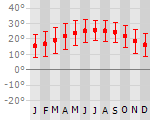
|
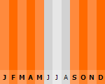
|
Typisch
| Officiële landsnaam | Verenigde Mexicaanse Staten |
| Hoofdstad | Mexico City |
| Nationaliteit | Mexicaan |
| Talen | Spaans |
| Visum nodig? | Nee |
| Munteenheid | Mexicaanse Peso (MXN) |
| Regeringsvorm | federale republiek |
| Grootte t.o.v. Nederland | 47.5 keer groter |
| Bevolking | 110.0 miljoen |
| Bevolkingsdichtheid t.o.v. Nederland | 7.2 keer lager |
| Laagste punt | -10 m |
| Hoogste punt | 5700 m |
Tags
tropisch woestijn steppe subtropisch bergklimaat Wintersport Duiken Backpacken Bergen Zee en strandLow-cost airlines
- Arke Fly
- Air Berlin
- Martinair
- Thomas Cook
Exotische ziekten
- hepatitis A
- typhus
- dengue
- leptospirosis
Interessante boeken over Mexico
-
Wegenkaart - Landkaart Mexico Yucatan Peninsula | ITMB | 10.95 €
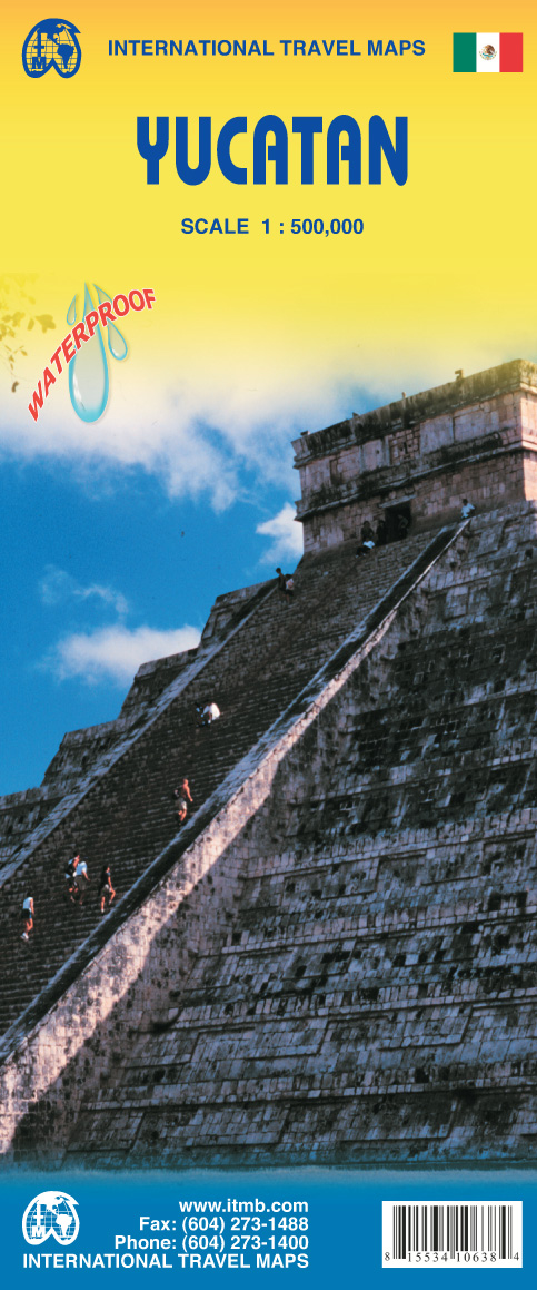
Een degelijke kaart met aanduidingen van o.a. nationale parken, vliegveld, benzinepomp, dirt-roads en kleine plattegrond van hoofdstad. Als... meer
Een degelijke kaart met aanduidingen van o.a. nationale parken, vliegveld, benzinepomp, dirt-roads en kleine plattegrond van hoofdstad. Als overzichtskaart goed te gebruiken.This is a modest upgrading, with little change over the previous edition; same cover, same ISBN, same price. We ran out of copies faster than expected and found few changes necessary to make to the artwork. Yucatan is one of those parts of Mexico seemingly unaffected by the Drug Wars, which appear to be tapering off in any case, and is as popular as ever.Legend Includes:Roads by classification, International Airports, Domestic Airports, Lighthouses, Points of Interest, Archaeological Sites, Beaches, Caves, Gas Stations, Reefs, National Parks, Swamps, Mangroves, Temples, Camp Ground, Museums, Forts, Shipwrecks, Sinkholes, Border Crossings, Harbours, Churches, Monasteries, Mines, Other Archaeological Remains, Trailer Parks, Airstrip, Viewpoints, Cultural World Heritage, Fishing, Paragliding, Diving, Sailing, Surfing, Hospitals, Accommodations, Universities, and much more. -
Landenreeks Mexico | KIT Publishers | 14.50 €

Mexico beschikt over grote natuurlijke rijkdommen. Alles wat de natuur heeft bedacht kan er groeien. Toch geeft het land jaarlijks miljarden uit aan... meer
Mexico beschikt over grote natuurlijke rijkdommen. Alles wat de natuur heeft bedacht kan er groeien. Toch geeft het land jaarlijks miljarden uit aan de import van voedsel. Decennia van verwaarlozing van het platteland eisen hun tol. Het vrijhandelsverdrag met de Verenigde Staten heeft de voedselafhankelijkheid verder vergroot.
Toch is Mexico bepaald geen arm land. Na Brazilië is het de tweede economie van Latijns-Amerika; wereldwijd neemt Mexico de twaalfde plaats in. Maar de kloof tussen rijk en arm, tussen de noordelijke en de zuidelijke staten en tussen stad en platteland, is enorm. Terwijl in de welvarende regio’s de kwaliteit van het leven vergelijkbaar is met een land als Spanje, komt die elders niet boven dat van de armste Afrikaanse landen uit. In die gebieden wonen vrijwel alle twaalf miljoen inheemse Mexicanen.
Grote vooruitgang is wel geboekt in het onderwijs. Negen van de tien kinderen volgen nu basisonderwijs. Maar hun kansen op de arbeidsmarkt zijn gering. De massa-emigratie van Mexicanen naar de Verenigde Staten houdt onverminderd aan. Zolang de economische situatie in Mexico niet verbetert, zal de ‘mexicanisering’ van de VS doorgaan.De Landenreeks is de betrouwbare bron van informatie over meer dan zestig land en in de wereld. De Landenreeks geeft een toegankelijk beeld van waar het in een land nu werkelijk om draait. Zonder in clichés te vervallen, schetst de reeks het gewone en het bijzondere van een land, en legt ook het karakteristieke van zijn bevolking bloot. Grensverleggend en onmisbaar.
Vluchten naar Mexico
-

Amsterdam naar Mexico stad vanaf 1069.19 €
-

Amsterdam naar Cancun vanaf 930.00 €
Vakantiebestemmingen met vergelijkbare kenmerkenMisschien bent u ook geïnteresseerd in andere vakantielanden met de volgende kenmerken: |
Reis en Vakantie Top 10Mexico is vertegenwoordigd in de volgende reis top10's:
|

- © 2010-2015 top10gezien.nl
- over deze site
- disclaimer
- adverteren
- contact