Highlights van Namibië
Natuur
- Etosha - enorme zoutvlakte


World Heritage Sites
- Twyfelfontein

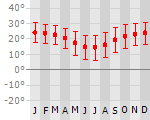
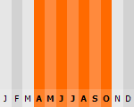
Klimaat
| Kenmerken |
|
| Temperatuur | Beste tijd voor een reis |
|
|
Typisch
| Officiële landsnaam | Republiek Namibië |
| Hoofdstad | Windhoek |
| Nationaliteit | Namibier |
| Talen | engels, Duits |
| Visum nodig? | Nee |
| Munteenheid | Namibische Dollar (NAD; ZAR) |
| Regeringsvorm | republiek |
| Grootte t.o.v. Nederland | 19.9 keer groter |
| Bevolking | 2.1 miljoen |
| Bevolkingsdichtheid t.o.v. Nederland | 158.4 keer lager |
| Laagste punt | 0 m |
| Hoogste punt | 2606 m |
Low-cost airlines
- Air Berlin
Exotische ziekten
- malaria
- hepatitis A
- typhus
Interessante boeken over Namibië
-
Wegenkaart - landkaart Namibië - Namibia | Freytag & Berndt | 10.50 €
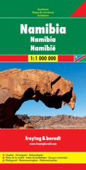
Uitstekende kaart van Namibië. Met index, Nationale parken en afstanden in kilometers. Goed kaartbeeld, register. Wel een vrij grote lap van ee... meer
Uitstekende kaart van Namibië. Met index, Nationale parken en afstanden in kilometers. Goed kaartbeeld, register. Wel een vrij grote lap van een kaart, maar prima in detail en geen probleem in de auto / camper.
De berijdbare wegen zijn goed weergeven, zowel de hoofdwegen als provinciale en lokale wegen; wegnummers worden vermeld. Afstanden tussen plaatsen zijn in kilometers op de kaart ingetekend, daarnaast worden ook op belangrijke plekken benzinepompen gemarkeerd.
In het kaartbeeld wordt door middel van schaduw het reliëf weergegeven en soms enkele punten in het landschap met de daadwerkelijke hoogte. Provinciegrenzen zijn goed terug te vinden, nationale parken en reservaten ook. Met allerhande symbolen worden toeristische bezienswaardigheden weergegeven als monumenten, historisch belangrijke plekken en uitzichtpunten. In bepaalde plaatsen zijn hotels en campings te vinden, luchthavens, treinverbindingen en havens vindt u er ook op!
-
Reisgids Zuid-Afrika en Namibië | Trotter Lannoo | 17.95 €

Veel aandacht voor praktische informatie als hotels en restaurants, maar ook, soms wat beperkte beschrijvingen van bezienswaardigheden. Handig zijn de... meer
Veel aandacht voor praktische informatie als hotels en restaurants, maar ook, soms wat beperkte beschrijvingen van bezienswaardigheden. Handig zijn de vele plattegronden: verrassend en verfrissend geschreven! Meer aandacht voor Zuid Afrika, weinig over Namibie.
Vakantiebestemmingen met vergelijkbare kenmerkenMisschien bent u ook geïnteresseerd in andere vakantielanden met de volgende kenmerken: |
Reis en Vakantie Top 10Namibië is vertegenwoordigd in de volgende reis top10's:
|

- © 2010-2015 top10gezien.nl
- over deze site
- disclaimer
- adverteren
- contact