Highlights van Panama


World Heritage Sites
- Fortificaties aan de Caraïbische zijde van Panama: Portobelo San Lorenzo
- Nationaal park Darién
- Nationaal park Talamanca Range La Amistad Reserves/La Amistad
- Archeologische plaats Panamá Viejo en het historische district van Panama-stad
- Nationaal Park Coiba

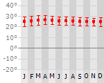
Klimaat
| Kenmerken |
|
| Temperatuur | Beste tijd voor een reis |
|

|
Typisch
| Officiële landsnaam | Republiek Panama |
| Hoofdstad | Panama City |
| Nationaliteit | Panamees |
| Talen | Spaans |
| Visum nodig? | Nee |
| Munteenheid | Balboa (PAB; USD) |
| Regeringsvorm | constitutionele democratie |
| Grootte t.o.v. Nederland | 1.9 keer groter |
| Bevolking | 3.3 miljoen |
| Bevolkingsdichtheid t.o.v. Nederland | 9.5 keer lager |
| Laagste punt | 0 m |
| Hoogste punt | 3475 m |
Exotische ziekten
- malaria
- hepatitis A
- dengue
- leptospirosis
Interessante boeken over Panama
-
Wegenkaart - Landkaart Panama | ITMB | 10.95 €
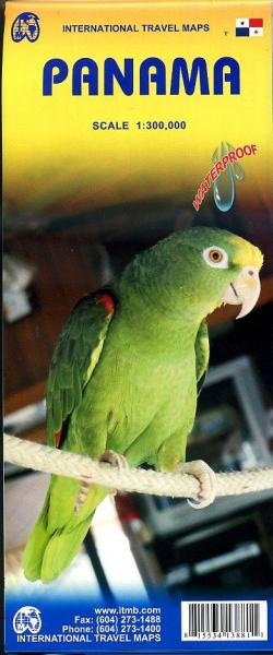
Een degelijke kaart met aanduidingen van o.a. nationale parken, vliegveld, benzinepomp, dirt-roads en kleine plattegrond van hoofdstad. Als overzich... meer
Een degelijke kaart met aanduidingen van o.a. nationale parken, vliegveld, benzinepomp, dirt-roads en kleine plattegrond van hoofdstad. Als overzichtskaart goed te gebruiken.
Panama on an indexed, double-sided map from ITMB, printed on waterproof and tear-resistant plastic paper, with large, clear street plan of central Panama City highlighting various places of interest and tourist facilities, including 18 selected hotels.
The map divides the country east/west, with some overlap between the two sides. Topography is shown by altitude colouring with spot heights and names of mountain ranges. Swaps, mangrove and salt marshes are marked, and national parks or protected areas and Indian Reserves highlighted.
The map shows the country’s road network with locations of petrol stations and border crossings, plus railways and local airports or landing grounds. Internal administrative boundaries are shown with names of the provinces. Symbols highlight various places of interest, archaeological sites, hot springs, beaches, diving or surfing sites, fishing areas, turtle protection zones, etc. Also marked is the course of the Trans-Panamanian oil pipeline. The map is indexed and has latitude and longitude lines at intervals of 30’.
A large inset shows the central part of Panama City, indicating 18 selected hotels, places of interest and various facilities.
Legend Includes:
Roads by classification, rivers, lakes, national parks and protected areas, airports, ports, gas stations, police checkpoints, museums, beaches, hot springs, archeological sites, lighthouses, viewpoints, outdoor activities, points of interest and other information. -
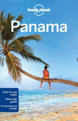
Reisgids Lonely Planet Panama | Lonely Planet | 22.95 €
De perfecte reisgids voor zowel de georganiseerde als de zelfstandige reiziger. Naast een algemene inleiding van het land / streek vol met praktisch... meer
De perfecte reisgids voor zowel de georganiseerde als de zelfstandige reiziger. Naast een algemene inleiding van het land / streek vol met praktische informatie over hoe je er het beste kunt reizen: slapen, eten, vervoer, excursies ... alles kun je er in vinden. Engelstalig. Lonely Planet
The roar of the howler monkey, the squawk of the macaw - Panama's a cacophony of wildlife, both natural and manmade. Get a bellyful of tapas in Panama City, hit the rip-roaring white-water of the Rio Chiriqui, explore wild stretches of the Darién Gap then sit back and watch a flaming sunset in the laid-back Archipiélago de Bocas del Toro. Let this guide, peppered with local voices, help you discover the real Panama.
With vibrant colonial cities, surviving indigenous cultures, lush tropical rainforest, killer surf and pockets of Caribbean island paradise, Panama has a little something for everyone!
tailored itineraries help you get the most out of your Panama adventure
unique Green index makes ecofriendly travel easy
69 detailed and easy-to-use maps
the world's best-selling guide to Panama

Vakantiebestemmingen met vergelijkbare kenmerkenMisschien bent u ook geïnteresseerd in andere vakantielanden met de volgende kenmerken: |
Reis en Vakantie Top 10Panama is vertegenwoordigd in de volgende reis top10's:
|

- © 2010-2015 top10gezien.nl
- over deze site
- disclaimer
- adverteren
- contact