Highlights van Peru

Peru is waarschijnlijk het bekendste Zuid-Amerikaanse land. En niet voor niets: het is goed bereisbaar en heeft grote hoogtepunten zoals Machu Picchu die een vakantie naar Peru onvergetelijk maken. Het noorden van Peru is relatief onbekend. Juist daar zijn veel pareltjes te vinden: lange verlaten, hagelwitte stranden en schattige Andes dorpjes zoals Caraz. Of je een lekkere strandvakantie wilt, feesten in wereldstad Lima, of ver weg van de gebaande paden in het tropisch regenwoud, in Peru kun je met je vakantie alle kanten op
Natuur
- Paracas Nationaal Reservaat - onherbergzame kustrotsen door miljoenen jaren wind en getij uitgesleten
- Cotahuasi en Colca kloven - een van de diepste kloven ter wereld (3535 en 3200 meter respectievelijk)
- Huascaran - de besneeuwde bergtoppen van de Andes
- Remote Amazone woud rond de plaats Puerto Maldonado en Nationaal Park Manu


Cultuur
- Machu Picchu - deze inca stad is door de prachtige ligging een van de hoogtepunten van een reis door Zuid-Amerika
- Nazca lijnen - mysterieuze eeuwenoude lijnen getekend in het woestijnzand
- Ruïne van Kuelap
- Piramides van Túcume uit het pre-inca tijdperk
- Puerto Bélen - het Venetië van Peru
- Archeologische overblijfselen van Chavin in de Andes
Sport en avontuur
- Surfen op de zandduinen van de Hucacachina Oase
- Máncora, laid-back surfdorpje in het noorden van Peru
- Inca trail - de populairste trekking ter wereld brengt je in vier dagen door prachtige natuur naar Machu Picchu
- Bergbeklimmen in de Cordillera Blanca
Mooiste routes
- De waanzinnige busrit van Chimbote naar Caraz door de Andes - gordels vast!
- Met een vrachtschip door de Amazone
- De noordelijke 'niet-bestaande' route langs het Titicaca-meer (Puno, Juliaca) naar de grens met Bolivia. Als je geluk hebt maak je op de grens een heuse smokkelaarsmarkt mee!
Overige mooiste bezienswaardigheden, evenementen, activiteiten en attracties
- Zonnewendefestival op 24 juni, Saqsaywaman
World Heritage Sites
- De stad Cuzco
- Historisch heiligdom van Machu Picchu
- Archeologische plaats Chavin
- Nationaal park Huascaran
- Archeologische zone Chan Chan
- Nationaal park Manú
- Historisch centrum van de stad Lima
- Nationaal park Rio Abiseo
- Lijnen en geogliefen van Nazca en Pampas de Jumana
- Historisch centrum van de stad Arequipa

Typisch
| nationale gerechten | Ceviche - rauwe vis met ui |
| nationale dranken | pisco sour |
| beroemd om | oude inca steden Andes Spaanse architectuur |
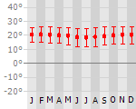
Klimaat
| Kenmerken |
|
| Temperatuur | Beste tijd voor een reis |
|

|
Typisch
| Officiële landsnaam | Republiek Peru |
| Hoofdstad | Lima |
| Nationaliteit | Peruaan |
| Talen | overig, Spaans |
| Visum nodig? | Nee |
| Munteenheid | Sol (PEN) |
| Regeringsvorm | constitutionele republiek |
| Grootte t.o.v. Nederland | 30.9 keer groter |
| Bevolking | 29.2 miljoen |
| Bevolkingsdichtheid t.o.v. Nederland | 17.7 keer lager |
| Laagste punt | 0 m |
| Hoogste punt | 6768 m |
Don't do this
- Titicaca vanuit Puno meer is heel toeristisch - wil je het mooier zien, ga dan vanuit de Boliviaanse kant
Exotische ziekten
- malaria
- hepatitis A
- typhus
- dengue
- gele koorts
- leptospirosis
Interessante boeken over Peru
-
Wegenkaart - Landkaart Lima & Central Peru | ITMB | 9.75 €

Peru is one of the most popular travel destinations in South America, and everyone going there arrives in Lima, which is a very large and complicated ... meer
Peru is one of the most popular travel destinations in South America, and everyone going there arrives in Lima, which is a very large and complicated city. In this edition, we have updated all the information for the city, covering the portion between the ocean and the historic centre and southerly to the Miraflores district. Lima is not blessed with a good rapid transit system, but we show the two lines and the busway, embassies, hotels, shopping areas, historic sites etc. the new part of the map is a detailed travel map of the central portion of Peru on the other side. This side would be particularly useful for those visitors planning to travel from Lima to Cuzco, or Pisco, or north to Cajamarca., or even into the upper reaches of the Amazon. It has excellent road information, and hundreds of touristic points of interest are noted on the map. This map is printed double-sided, on paper.
Legend Includes:
Roads by classification, parks, sanctuaries, native tribes, churches, ruins, springs, museums, lodges, beaches, world heritage sites, Inca culture, tourist information, public transit, points of interest and other information.Lima 1:13.000
Centraal Peru 1:1.500.000 -
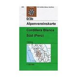
Wandelkaart 0/3b Cordillera Blanca Sud Peru | Alpenvereinskarte | 15.25 €
Zeer gedetailleerde kaarten: wandelroutes hebben naar gelang de zwaarte onderscheidende markeringen, gletsjerpassen staan aangegeven en de vers... meer
Zeer gedetailleerde kaarten: wandelroutes hebben naar gelang de zwaarte onderscheidende markeringen, gletsjerpassen staan aangegeven en de verschillende soorten hutten zijn ingetekend. De grondlaag van deze kaarten wordt gevormd door topografische kaarten, waardoor deze kaarten heel waardevol zijn voor elke beginnende en gevorderde wandelaar of klimmer.
Darstellung: Kartengrundlage vom "Instituto Geográfico Nacional", Lima-Perú (amtliche peruanische Karte).
Höhenlinienabstand: 50m
Anzahl der Farben: 7
Format des Karteninhalts: 60cm x 94cm
Gletscherstand: 2002
Vakantiebestemmingen met vergelijkbare kenmerkenMisschien bent u ook geïnteresseerd in andere vakantielanden met de volgende kenmerken: |
Reis en Vakantie Top 10Peru is vertegenwoordigd in de volgende reis top10's: |

- © 2010-2015 top10gezien.nl
- over deze site
- disclaimer
- adverteren
- contact