Highlights van Sint Lucia


World Heritage Sites
- geen

Typisch
| nationale gerechten | gedroogde en gezouten kabeljauw |
Klimaat
| Kenmerken |
|
| Temperatuur | Beste tijd voor een reis |
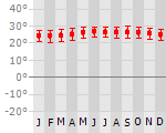
|
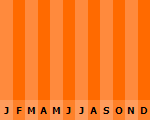
|
Typisch
| Officiële landsnaam | Saint Lucia |
| Hoofdstad | Castries |
| Nationaliteit | Sint-luciaan |
| Talen | engels |
| Visum nodig? | Nee |
| Munteenheid | Oost Caribische Dollar (XCD) |
| Regeringsvorm | parlementaire democratie |
| Grootte t.o.v. Nederland | 67.4 keer kleiner |
| Bevolking | 0.2 miljoen |
| Bevolkingsdichtheid t.o.v. Nederland | 1.4 keer lager |
| Laagste punt | 0 m |
| Hoogste punt | 950 m |
Interessante boeken over Sint Lucia
-
Reisgids St. Lucia | Thomas Cook Pocket Guide | Thomas Cook Publishing,Polly Thomas 10.50 €
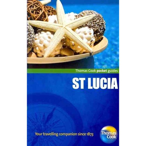
Engelstalig gidsje over St. Lucia met alle hoogtepunten en boordevol praktische informatie, zoals resorts, excursies en lifestyles. This vibrant s... meer
Engelstalig gidsje over St. Lucia met alle hoogtepunten en boordevol praktische informatie, zoals resorts, excursies en lifestyles.
This vibrant series covers over 170 destinations worldwide, from cosmopolitan urban delights to sun-kissed beach idylls. Bursting with insightful and easily accessible information, these guides are full of practical tips on how to make the most of a city break or longer holiday.
-
Wegenkaart - landkaart Saint Lucia | ITMB | 10.95 €
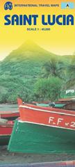
Een degelijke kaart met aanduidingen van o.a. nationale parken, vliegveld, benzinepomp, dirt-roads en kleine plattegrond van hoofdstad. Als overzichts... meer
Een degelijke kaart met aanduidingen van o.a. nationale parken, vliegveld, benzinepomp, dirt-roads en kleine plattegrond van hoofdstad. Als overzichtskaart goed te gebruiken.
Saint Lucia is one of the loveliest and most popular of the Caribbean island states. It is an ideal vacation travel destination, with excellent beaches, snorkelling, and accommodation facilities. It is also the hub of Carib ferry services, with boats plying between Castries, the capital, and St. Vincent to the south and Martinique to the north. This new service allows island-hopping to be practical for those on a budget, or those wishing to have a pleasant sea cruise combined with the opportunity to visit other islands. The map itself is at an excellent scale, shows physical features as well as roads, and locates all current touristic activity. This is a place I want to ground-truth this winter! Printed on paper, single-sided, inset of Castries.
Legend Includes:
Roads by classification, Highways , Main Roads, Minor Roads, Dirt Roads, Hiking Trails, Larger Urban Areas, Smaller Urban Areas, Parks, UNESCO World Heritage Sites, Diving / Scuba Locations or Dive-shops, Points of Interest / Churches, Hotels / Accommodations, Gas / Petrol Stations, Marinas / Sea Ports / Watersports, Coral Reefs, Camping / Hot Springs / Caves, Park Areas, Industrial / Parking, Institutional Areas, Attractions / Shopping, Cruise Ship Terminals / Shopping / Restaurants, Police Stations / Post Offices / Churches, Hospitals / Embassies / Schools, Regional Boundaries and more.
Vakantiebestemmingen met vergelijkbare kenmerkenMisschien bent u ook geïnteresseerd in andere vakantielanden met de volgende kenmerken: |
Reis en Vakantie Top 10Sint Lucia is vertegenwoordigd in de volgende reis top10's:
|

- © 2010-2015 top10gezien.nl
- over deze site
- disclaimer
- adverteren
- contact