Highlights van Tunesië


World Heritage Sites
- Het amfitheater van El Djem
- Locatie van Carthago
- Medina van Tunis
- Nationaal park Ichkeul
- Punische stad Kerkuane en haar necropolis
- Medina van Sousse
- Kairouan
- Dougga/Thugga

Typisch
| nationale gerechten | Brik |
Klimaat
| Kenmerken |
|
| Temperatuur | Beste tijd voor een reis |
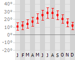
|
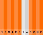
|
Typisch
| Officiële landsnaam | Republiek Tunesië |
| Hoofdstad | Tunis |
| Nationaliteit | Tunesier |
| Talen | arabisch, frans |
| Visum nodig? | Nee |
| Munteenheid | Tunesische Dollar (TND) |
| Regeringsvorm | republiek |
| Grootte t.o.v. Nederland | 3.9 keer groter |
| Bevolking | 10.4 miljoen |
| Bevolkingsdichtheid t.o.v. Nederland | 6.3 keer lager |
| Laagste punt | -17 m |
| Hoogste punt | 1544 m |
Low-cost airlines
- Arke Fly
- Air Berlin
- Transavia
- Corendon
- Thomas Cook
Interessante boeken over Tunesië
-
Reisgids Lonely Planet Tunisia - Tunesie | Lonely Planet | 21.25 €
.jpg)
De perfecte reisgids voor zowel de georganiseerde als de zelfstandige reiziger. Naast een algemene inleiding van het land / streek vol met praktisch... meer
De perfecte reisgids voor zowel de georganiseerde als de zelfstandige reiziger. Naast een algemene inleiding van het land / streek vol met praktische informatie over hoe je er het beste kunt reizen: slapen, eten, vervoer, excursies ... alles kun je er in vinden.
Lonely Planet: Our latest Tunisia book, guides you through the Sahara on camelback and reveals the best amber-sanded beaches. We'll help you navigate the tangled alleys of the Tunis medina, explore the enchanting Roman ruins of Dougga and hike the Kroumirie Mountains' famous cork oak forests.
* 76 Detailed & easy to use Maps
* INCLUDES in-depth chapter exploring the Sahara
* RELAX with our pick of the best beaches
* TASTE authentic local cuisine with our expert guide -
Landkaart - Wegenkaart Tunisia - Tunesië | ITMB | 10.95 €
Uitstekende wegenkaart van Tunesie met zowel de toeristische informatie als Nationale Parken en bezienswaardigheden, maar ook de topografische details... meer
Uitstekende wegenkaart van Tunesie met zowel de toeristische informatie als Nationale Parken en bezienswaardigheden, maar ook de topografische details als plaatsen en wegen, spoorlijnen en rivieren, hoogten, lengte- en breedtegraden.
Folded road and travel map. Scale 1:800,000. Distinguishes roads ranging from primary paved roads to other roads/tracks (poor quality). Legend includes railroads, ferry routes, coral reefs, international/national airports, airfields, train depots, gas stations, hospitals/clinics, border crossings, wells, oasis, lodging, rest/guest houses, hostels, campsites/huts, parks/reserves, beaches, scuba diving sites, golf courses, points of interest, Kasba's, archaeological sites, ruins, forts, potteries, mueums, churches, mosques. Includes inset map of Tunis (central). Indexed.

Vakantiebestemmingen met vergelijkbare kenmerkenMisschien bent u ook geïnteresseerd in andere vakantielanden met de volgende kenmerken: |
Reis en Vakantie Top 10Tunesië is vertegenwoordigd in de volgende reis top10's: |

- © 2010-2015 top10gezien.nl
- over deze site
- disclaimer
- adverteren
- contact