Highlights van Zuid-Afrika
Natuur
- Kruger National Park
- Marakele Wildpark - natuurpark van een Nederlandse ondernemer
- Drakensberge - waanzinnige hoeveelheid plantensoorten en de aanwezigheid van een grote diversiteit aan dieren maken dit gebied een must-see


World Heritage Sites
- Moeraslandpark Greater St. Lucia
- Robbeneiland
- De gebieden met fossielen van hominides in Sterkfontein & Swartkrans & Kromdraai en omgeving
- Nationaal park Drakensberg
- Cultureel landschap Mapungubwe
- De beschermde gebieden van de Floraregio van de Kaap
- Vredefortkrater
- Het Cultureel en botanisch landschap van Richtersveld

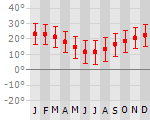
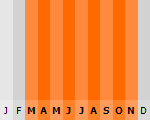
Klimaat
| Kenmerken |
|
| Temperatuur | Beste tijd voor een reis |
|
|
Typisch
| Officiële landsnaam | Republiek Zuid-Afrika |
| Hoofdstad | Pretoria |
| Nationaliteit | Zuid-Afrikaan |
| Talen | overig, engels, Nederlands |
| Visum nodig? | Nee |
| Munteenheid | Rand (ZAR) |
| Regeringsvorm | republiek |
| Grootte t.o.v. Nederland | 29.4 keer groter |
| Bevolking | 43.8 miljoen |
| Bevolkingsdichtheid t.o.v. Nederland | 11.2 keer lager |
| Laagste punt | 0 m |
| Hoogste punt | 3408 m |
Tags
Bergen Zee en strand tropisch savanne woestijn steppe subtropisch mediterraan Wintersport Duiken Backpacken wildlifeLow-cost airlines
- Air Berlin
Exotische ziekten
- malaria
- hepatitis A
- typhus
Interessante boeken over Zuid-Afrika
-
Stadsplattegrond Cape Town - Kaapstad | 10.25 €
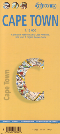
Borch Kaapstad is een duidelijke, geplastificeerde plattegrond van het centrum met informatie over openbaar vervoer en bezienswaardigheden. Inclusie... meer
Borch Kaapstad is een duidelijke, geplastificeerde plattegrond van het centrum met informatie over openbaar vervoer en bezienswaardigheden. Inclusief straatnamenregister.Our soft-laminated folded map of Cape Town shows: Cape Town 1:15 000, Cape Peninsula 1:140 000, Cape Town and Region 1:635 000, Garden Route 1:3 000 000, Robben Island 1:40 000, South Africa administrative & time zones, Public Transport Cape Town. Borch Maps are easy to fold, durable and water-repellent with a wipeable surface. Borch Maps show hotels, museums, monuments, markets, public transport, top sights and points of interest, useful statistics, conversion charts for temperatures, weights and measurements, climate charts showing temperatures, sunshine hours, precipitation and humidity, overview maps, time zones, and much more...Cape Town, the legislative capital and second most populous city of South Africa and the provincial capital of the Western Cape, is also renowned as one of the world's most beautiful cities. South Africa's most popular tourist region covers almost 2,500 sq km (500 sq km of which is the city of Cape Town), has a relatively low population density, an agreeable Mediterranean climate and a flourishing economy with well-developed infrastructure. First inhabited about 12,000 years ago and colonized by Europeans in the 15th century, Cape Town underwent centuries of successive occupation before becoming today's democratic capital. Because of Cape Town's splendid natural surroundings and outdoor lifestyle, day trips to the countless natural sights can be enjoyed by everyone and visitors can participate in many activities - from surfing or whale and dolphin-watching to visiting the national parks, hiking (or taking a cable-car) up Table Mountain or embarking on a wine-tasting trip into the Cape Winelands. You'll find the nightlife and restaurants are excellent and this city boasts great shopping venues, beautiful architecture, friendly locals and above all stunning scenery. -
Topografische kaart 3128 Umtata-Oostelijke Kaap - Zuid Afrika | | 24.90 €
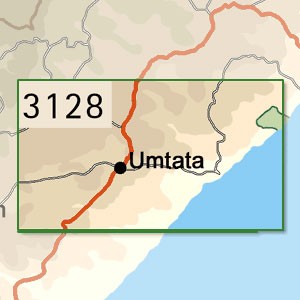
Topografische Detailkaart van de Oostelijke Kaap met duidelijke hoogteverschillen. Beslaat de districten Umtata, Tsolo, Libode, Ngqeleni, Lusikisiki... meer
Topografische Detailkaart van de Oostelijke Kaap met duidelijke hoogteverschillen. Beslaat de districten Umtata, Tsolo, Libode, Ngqeleni, Lusikisiki Umzimvubu, grotendeels Mqanduli en deels aanliggende districten.
Oppervlakte van 31° ZB 28° OL tot 32° ZB 30° OL.
Surveys and Mapping, MowbrayTopo-Cadastral Map of South Africa, 1:250.000Gauss conform projectionMap range: 31°-32°South; 28°-30°EastMap grid: yesPaper, one-sided colour printDieses Kartenwerk deckt Südafrika im Maßstab 1:250.000 ab und besteht aus insgesamt 70 einzelnen Kartenblättern. Diese Karte hier ist eine davon. Der Maßstab 1:250.000 bedeutet, daß Sie 250.000 Zentimeter (2,5 Kilometer) aus der Natur in einem Zentimeter auf der Karte wiederfinden und das in sehr guter Qualität und Genauigkeit. Farmen beispielsweise werden mit Namen und sogar mit deren Farmgrenzen dargestellt.
Vakantiebestemmingen met vergelijkbare kenmerkenMisschien bent u ook geïnteresseerd in andere vakantielanden met de volgende kenmerken: |
Reis en Vakantie Top 10Zuid-Afrika is vertegenwoordigd in de volgende reis top10's:
|

- © 2010-2015 top10gezien.nl
- over deze site
- disclaimer
- adverteren
- contact